

Vulnerability Assessment of Composite Disaster Systems in Guangdong−Hong Kong−Macao Greater Bay Area
-
摘要:
自然灾害之间相互作用形成复杂灾害链,致使复合灾害引发的损失更为严重. 为量化复合链生灾害风险并评估区域面对复杂灾害链的脆弱性,有效推进灾害风险防范工作,考虑灾害链的触发和叠加(折减)效应,从承灾体暴露度、孕灾环境敏感性和适应性3个维度,构建复合灾害系统脆弱性评估指标体系,进而建立串联式复合灾害承灾体暴露度、孕灾环境敏感性和适应性评估模型,并加权得到串联式复合灾害系统脆弱性评估模型. 以粤港澳大湾区暴雨-滑坡灾害链为例,结合卷积神经网络(CNN)、参数最优地理探测器-层次分析法耦合模型(OPGD-AHP) 、序关系法-TOPSIS (G1-TOPSIS)、熵权-TOPSIS等方法,计算得出粤港澳大湾区暴雨、滑坡,以及暴雨-滑坡灾害链的脆弱性指数,采用ArcGIS工具进一步绘制了对应的脆弱性等级统计图. 研究结果表明:粤港澳大湾区暴雨-滑坡灾害链脆弱性呈现出西部地区多高和较高脆弱区,中西部、西南部和东北部多中脆弱区,中部、中南部和东部多低和较低脆弱区的分布特征;同一区域面对不同单灾种的脆弱性之间,除了叠加关系,还存在一定的触发和协同效应,尤其是在高脆弱区与高脆弱区之间,以及低脆弱区与低脆弱区之间. 成果可在复合灾害系统脆弱性评估工作中推广应用,为我国复合灾害系统风险评估与减灾防灾提供技术支撑.
Abstract:The interaction between natural disasters forms a complex disaster chain, making the losses caused by composite disasters more severe. To quantify the risk of disasters caused by complex disaster chains, explore the vulnerability level of regions to complex disaster chains, and effectively promote disaster risk prevention work, the triggering and superposition (reduction) effects of disaster chains were considered. A vulnerability assessment index system for composite disaster systems was constructed from three dimensions: exposure of disaster-bearing bodies, susceptibility, and adaptability of disaster-prone environments. A series of models for assessing the exposure degree of composite disaster-bearing bodies, disaster-prone environmental sensitivity, and adaptability was established through derivation. Subsequently, they were weighted to obtain a series of vulnerability assessment models for composite disaster systems. By taking the rainstorm-landslide disaster chain in the Guangdong−Hong Kong−Macao Greater Bay Area as an example, the vulnerability index of rainstorm, landslide, and rainstorm-landslide disaster chain in the Greater Bay Area was calculated by combining convolutional neural network (CNN), coupling model of a parameter optimal geographical detector and analytic hierarchy process (OPGD-AHP), G1 method-Technique for Order Preference by Similarity to Ideal Solution (G1-TOPSIS), and entropy weight-TOPSIS, and the corresponding vulnerability level zoning map was further drawn by using ArcGIS tools. The research results indicate that the vulnerability of the rainstorm-landslide disaster chain is high and relatively high in the western region, medium in the central and western regions, as well as southwest and northeast regions, and low and relatively low in the central, central and southern regions, and eastern regions in the Greater Bay Area. There are not only overlapping relationships but also certain triggering and synergistic effects between the vulnerability of different single disaster types in the same region, especially between high vulnerability areas, as well as between low vulnerability areas. The results can be promoted and applied in the vulnerability assessment of composite disaster systems, providing technical support for risk assessment and disaster reduction and prevention of composite disaster systems in China.
-
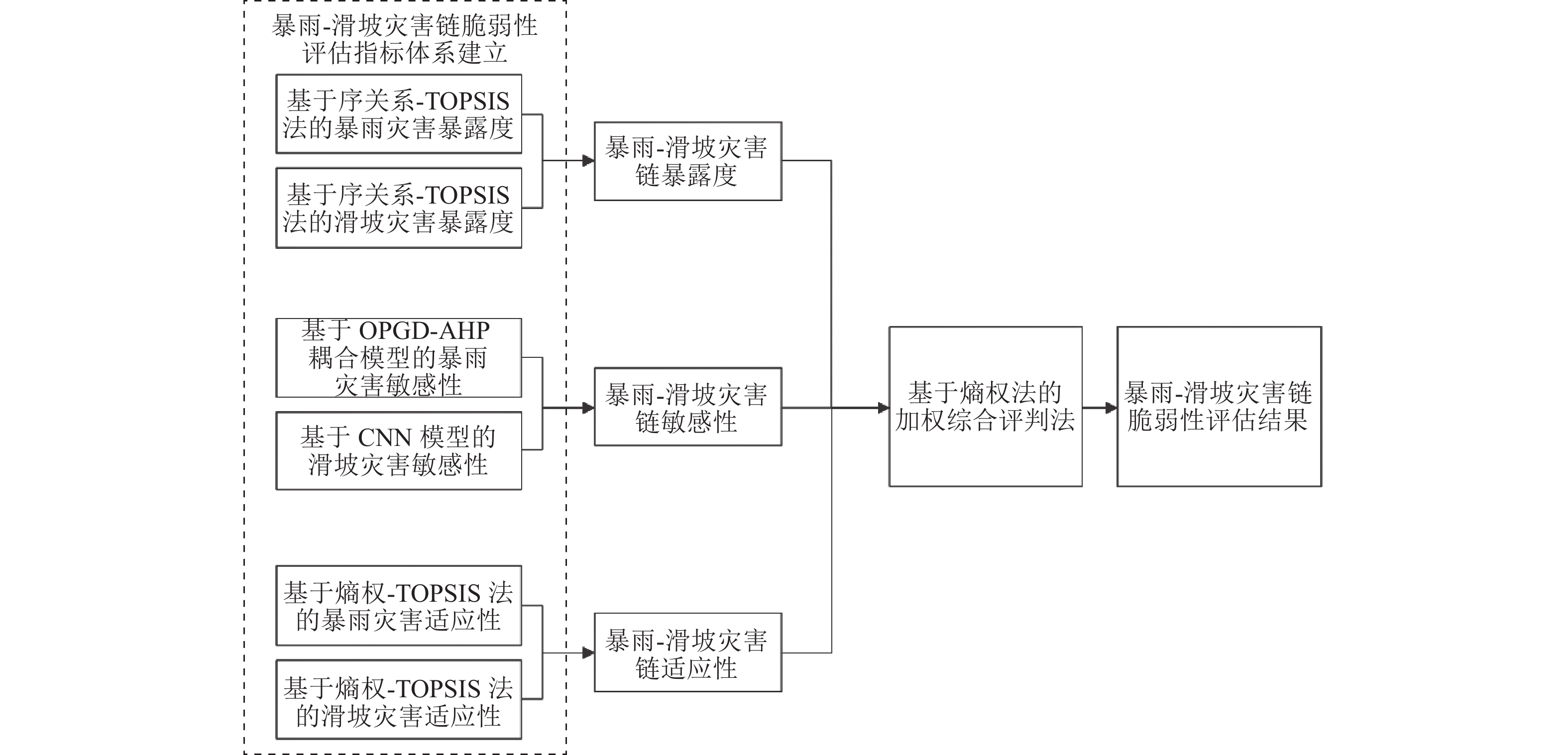
图 1 暴雨-滑坡灾害链脆弱性评估流程
Figure 1. Flowchart of vulnerability assessment of rainstorm-landslide disaster chain
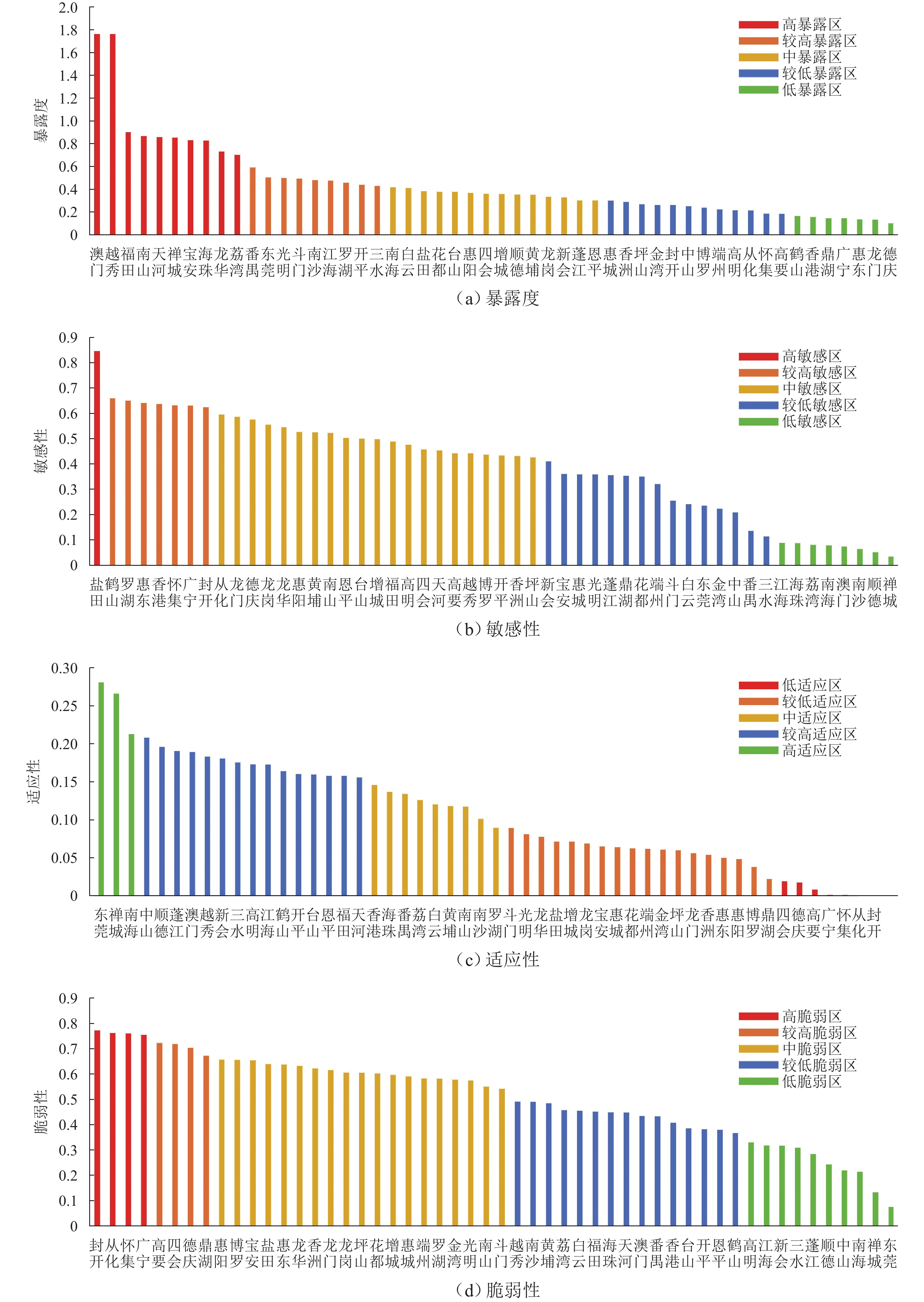
图 2 粤港澳大湾区暴雨-滑坡灾害链各维度与脆弱性分布
Figure 2. Distribution of dimensions and vulnerability of rainstorm-landslide disaster chain in Greater Bay Area
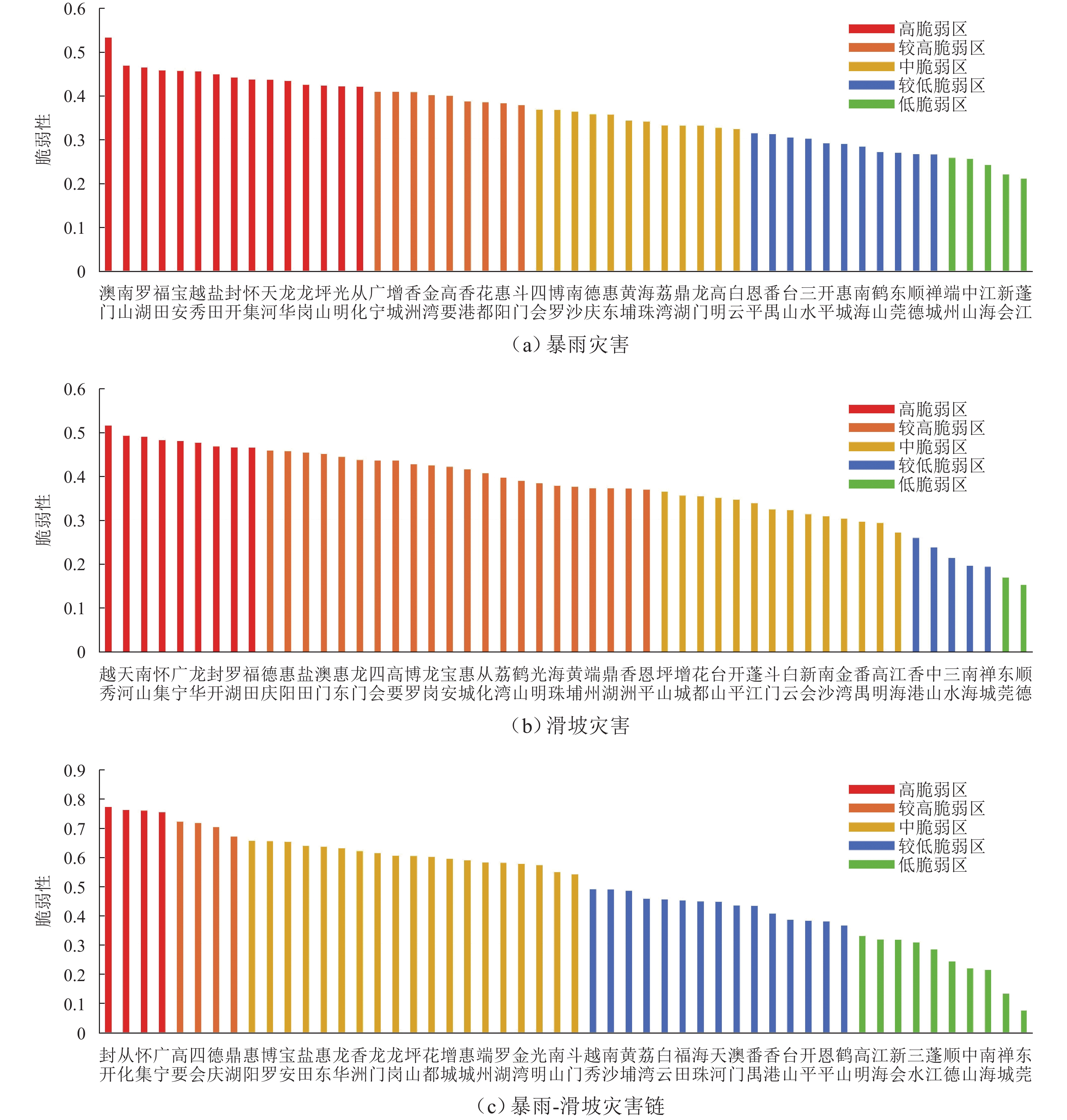
图 3 单灾种与灾害链脆弱性等级分布
Figure 3. Distribution of single disaster type and vulnerability level of disaster chain
表 1 暴雨-滑坡灾害链脆弱性评价指标体系
Table 1. Vulnerability assessment index system of rainstorm-landslide disaster chain
维度层 准则层 指标层 涉及灾种 暴露度 社会 居住用地 暴雨、滑坡 工业用地 暴雨、滑坡 道路密度 暴雨、滑坡 人口 人口密度 暴雨、滑坡 经济 耕地 暴雨、滑坡 地均 GDP 暴雨、滑坡 敏感性 水文 河网密度 暴雨 地质 地层岩性 滑坡 地表温度 暴雨 地形 高程 暴雨、滑坡 地形起伏度 暴雨、滑坡 海岸线距离 暴雨 坡向 滑坡 坡度 暴雨、滑坡 植被 NDVI 暴雨、滑坡 土地
利用土地利用类型 暴雨、滑坡 土地利用程度 滑坡 适应性 防灾
能力居民人均可支配收入 暴雨、滑坡 每 10 万常住人口中
大学程度人口数暴雨、滑坡 堤防长度 暴雨 地质隐患点防治能力 滑坡 地质灾害防治资金投入 滑坡 地质灾害监测预警能力 滑坡 应灾
能力15 岁以下及 65 岁以上
人口比例暴雨、滑坡 女性占比 暴雨、滑坡 每万人拥有医疗机构床位数 暴雨、滑坡 每万人拥有避灾点数量 暴雨、滑坡 排水管网密度 暴雨 水库库容占比 暴雨 政府应急救援能力 暴雨、滑坡 应急物资储备能力 暴雨、滑坡  下载: 导出CSV
表 2 粤港澳大湾区暴雨-滑坡灾害链脆弱性评估方法
Table 2. Vulnerability assessment methods of rainstorm-landslide disaster chain in Greater Bay Area
维度 权重确定方法 指标计算方法 暴露度 序关系分析法 TOPSIS 法 敏感性 OPGD-AHP 耦合模型,
CNN 模型ArcGIS 平台空间
加权叠加适应性 熵权法 TOPSIS 法
下载: 导出CSV
表 3 暴雨、滑坡灾害暴露度评估指标对应权重
Table 3. Weights of assessment indexes for rainstorm and landslide exposure degrees
指标 暴雨 滑坡 地均 GDP 0.22 0.18 耕地占比 0.10 0.12 居住用地占比 0.16 0.17 工业用地占比 0.10 0.14 道路密度 0.19 0.14 人口密度 0.23 0.25
下载: 导出CSV
表 4 暴雨-滑坡转化阈值与转化概率
Table 4. Threshold and probability of rainstorm-landslide transformation
降雨量区段/
mm占降雨总样本
比例/%该降雨区段滑坡样本数
占全部位移点数比例/%0~83.45 95.17 34.81 83.45~312.60 4.83 37.50 312.60 以上 0 0
下载: 导出CSV
表 5 暴雨灾害适应性评估指标对应权重
Table 5. Index weights of rainstorm adaptability assessment
指标 权重 堤防长度 0.24 居民人均可支配收入 0.14 每 10 万常住人口中大学程度人口数 0.09 每万人拥有医疗机构床位数 0.10 每万人拥有避灾点数量 0.06 应急物资储备能力 0.14 排水管道密度 0.03 水库库容占比 0.04 政府应急救援能力 0.08 15 岁以下及 65 岁以上人口比例 0.05 女性占比 0.03
下载: 导出CSV
表 6 滑坡灾害适应性评估指标对应权重
Table 6. Index weights of landslide adaptability assessment
指标 权重 地质隐患点防治能力 0.14 地质灾害防治资金投入 0.11 地质灾害监测预警能力 0.15 居民人均可支配收入 0.16 每 10 万常住人口中大学程度人口数 0.06 每万人拥有医疗机构床位数 0.04 每万人拥有避灾点数量 0.03 应急物资储备能力 0.08 政府应急救援能力 0.06 女性占比 0.08 15 岁以下及 65 岁以上人口比例 0.09
下载: 导出CSV
-
[1] 黄莉, 徐凤凰, 张晨钰, 等. 粤港澳大湾区复合灾害系统敏感性评估[J]. 水土保持学报, 2024, 38(1): 167-175.HUANG Li, XU Fenghuang, ZHANG Chenyu, et al. Sensitivity assessment of complex disaster system in Guangdong−Hong Kong−Macao Greater Bay Area[J]. Journal of Soil and Water Conservation, 2024, 38(1): 167-175. [2] 刘家宏, 梅超, 刘宏伟, 等. 特大城市外洪内涝灾害链联防联控关键科学技术问题[J]. 水科学进展, 2023, 34(2): 172-181.LIU Jiahong, MEI Chao, LIU Hongwei, et al. Key scientific and technological issues of joint prevention and control of river flood and urban waterlogging disaster chain in megacities[J]. Advances in Water Science, 2023, 34(2): 172-181. [3] 钟启明, 陈小康, 梅胜尧, 等. 滑坡堰塞湖溃决风险与过程研究进展[J]. 水科学进展, 2022, 33(4): 659-670.ZHONG Qiming, CHEN Xiaokang, MEI Shengyao, et al. A state of the art review on the failure risk and process of the landslide-induced dammed lake[J]. Advances in Water Science, 2022, 33(4): 659-670. [4] KATES R W, AUSUBEL J H, BERBERIAN M. Climate impact assessment: studies of the interaction of climate and society[M]. New York: Scientific Committee on Problems of the Environment, 1985: 25-28. [5] 杨飞, 马超, 方华军. 脆弱性研究进展: 从理论研究到综合实践[J]. 生态学报, 2019, 39(2): 441-453.YANG Fei, MA Chao, FANG Huajun. Research progress on vulnerability: from theoretical research to comprehensive practice[J]. Acta Ecologica Sinica, 2019, 39(2): 441-453. [6] ADGER W N. Vulnerability[J]. Global Environmental Change, 2006, 16(3): 268-281. doi: 10.1016/j.gloenvcha.2006.02.006 [7] GERÇEK D, GÜVEN İ T. Urban earthquake vulnerability assessment and mapping at the microscale based on the catastrophe progression method[J]. International Journal of Disaster Risk Science, 2023, 14(5): 768-781. doi: 10.1007/s13753-023-00512-y [8] ABDRABO K I, KANTOUSH S A, ESMAIEL A, et al. An integrated indicator-based approach for constructing an urban flood vulnerability index as an urban decision-making tool using the PCA and AHP techniques: a case study of Alexandria, Egypt[J]. Urban Climate, 2023, 48: 101426. doi: 10.1016/j.uclim.2023.101426 [9] 蒋新宇, 马雪莹, 杨丽娇. 回归分析框架下洪涝灾害脆弱性曲线构建方法综合比较研究[J]. 水利学报, 2023, 54(2): 184-198.JIANG Xinyu, MA Xueying, YANG Lijiao. Comprehensive comparative study on the construction method of flood vulnerability and fragility curves under the framework of regression analysis[J]. Journal of Hydraulic Engineering, 2023, 54(2): 184-198. [10] 陈军飞, 李倩, 邓梦华, 等. 基于随机森林与可变模糊集的城市洪涝脆弱性评估[J]. 长江流域资源与环境, 2020, 29(11): 2551-2562.CHEN Junfei, LI Qian, DENG Menghua, et al. Urban flood vulnerability assessment based on random forests and variable fuzzy sets[J]. Resources and Environment in the Yangtze Basin, 2020, 29(11): 2551-2562. [11] LIU Y, SHU B, CHEN Y, et al. Spatial vulnerability assessment of rural settlements in hilly areas using BP neural network algorithm[J]. Ecological Indicators, 2023, 157: 111278. doi: 10.1016/j.ecolind.2023.111278 [12] LI Y, GONG S Y, ZHANG Z R, et al. Vulnerability evaluation of rainstorm disaster based on ESA conceptual framework: a case study of Liaoning province, China[J]. Sustainable Cities and Society, 2021, 64: 102540. doi: 10.1016/j.scs.2020.102540 [13] 刘曙光, 郑伟强, 钟桂辉, 等. 基于脆弱性曲线的寿溪河流域村镇建筑洪灾风险评估[J]. 同济大学学报(自然科学版), 2024, 52(1): 68-76.LIU Shuguang, ZHENG Weiqiang, ZHONG Guihui, et al. Flood risk assessment of rural buildings in shouxihe basin based on vulnerability curve[J]. Journal of Tongji University (Natural Science), 2024, 52(1): 68-76. [14] 陈轶, 刘涛, 张峰, 等. 面向城市洪涝的社会脆弱性空间识别与规划策略: 以南京市为例[J]. 城市发展研究, 2023, 30(2): 23-31.CHEN Yi, LIU Tao, ZHANG Feng, et al. The spatial identification of social vulnerability to urban floods and planning strategy: a case study of Nanjing[J]. Urban Development Studies, 2023, 30(2): 23-31. [15] ZHENG H, DENG Z F, GUO L L, et al. Assessment of building physical vulnerability in earthquake-debris flow disaster chain[J]. International Journal of Disaster Risk Science, 2023, 14(4): 666-679. doi: 10.1007/s13753-023-00509-7 [16] 李国庆, 邢开成, 黄大鹏. 雄安新区社会重构期暴雨洪涝风险的社区分类调适[J]. 中国人口•资源与环境, 2020, 30(6): 53-63.LI Guoqing, XING Kaicheng, HUANG Dapeng. Community classification adaptation of rainstorm and flood risk prevention in the social restructuring period in the Xiongan New Area[J]. China Population, Resources and Environment, 2020, 30(6): 53-63. [17] 王军, 谭金凯. 气候变化背景下中国沿海地区灾害风险研究与应对思考[J]. 地理科学进展, 2021, 40(5): 870-882. doi: 10.18306/dlkxjz.2021.05.013WANG Jun, TAN Jinkai. Understanding the climate change and disaster risks in coastal areas of China to develop coping strategies[J]. Progress in Geography, 2021, 40(5): 870-882. doi: 10.18306/dlkxjz.2021.05.013 [18] 广东省统计局. 广东统计年鉴(2021)[M]. 北京: 中国统计出版社, 2021 [19] 广东省统计局. 广东省第七次全国人口普查公报[EB/OL].(2021-05-15)[2024-04-15]. https://stats.gd.gov.cn/dqcrkpc/pcyw/index.html. [20] 姚蕊, 杨群涛, 张书亮. 城市暴雨内涝灾害脆弱性研究综述[J]. 水资源保护, 2023, 39(1): 93-100.YAO Rui, YANG Quntao, ZHANG Shuliang. Review on vulnerability of urban rainstorm waterlogging disaster[J]. Water Resources Protection, 2023, 39(1): 93-100. [21] POLSKY C, NEFF R, YARNAL B. Building comparable global change vulnerability assessments: the vulnerability scoping diagram[J]. Global Environmental Change, 2007, 17(3/4): 472-485. [22] 宋柏泱, 陈报章. 巴基斯坦瓜达尔港地区干旱灾害风险评估[J]. 地理研究, 2022, 41(8): 2251-2264.SONG Boyang, CHEN Baozhang. Drought risk assessment in Gwadar port, Pakistan[J]. Geographical Research, 2022, 41(8): 2251-2264. [23] 涂鑫鑫, 李伟夫, 陈洪, 等. 基于主成分分析法的城中村居民社会脆弱性评估: 以武汉市洪山区为例[J]. 长江流域资源与环境, 2023, 32(2): 284-296.TU Xinxin, LI Weifu, CHEN Hong, et al. Assessment of social vulnerability in urban villages based on principal component analysis: taking Hongshan, Wuhan as an example[J]. Resources and Environment in the Yangtze Basin, 2023, 32(2): 284-296. [24] 杨新军, 温晓金, 陈佳. 脆弱性与恢复力整合: 社会—生态系统可持续性研究转型与挑战[J]. 人文地理, 2024, 39(2): 21-30.YANG Xinjun, WEN Xiaojin, CHEN Jia. The integration of vulnerability and resilience: research ransformations and challenges of sustainability of social-ecological systems[J]. Human Geography, 2024, 39(2): 21-30. [25] 包文轩, 宫阿都, 徐澯, 等. 基于区域灾害系统论的广东省台风灾害风险评估: 以“山竹” 台风为例[J]. 北京师范大学学报(自然科学版), 2023, 59(1): 94-103.BAO Wenxuan, GONG Adu, XU Can, et al. Typhoon disaster risk assessment in Guangdong province by regional disaster system theory: case of “Mangkhut”[J]. Journal of Beijing Normal University (Natural Science), 2023, 59(1): 94-103. [26] GARSCHAGEN M, DOSHI D, REITH J, et al. Global patterns of disaster and climate risk: an analysis of the consistency of leading index-based assessments and their results[J]. Climatic Change, 2021, 169(1): 11. [27] MING X D, LIANG Q H, DAWSON R, et al. A quantitative multi-hazard risk assessment framework for compound flooding considering hazard inter-dependencies and interactions[J]. Journal of Hydrology, 2022, 607: 127477. doi: 10.1016/j.jhydrol.2022.127477 [28] 刘强, 汤爱平. 基于概率分析的公路系统灾害风险研究[J]. 西南交通大学学报, 2021, 56(6): 1268-1274, 1289.LIU Qiang, TANG Aiping. Highway system disaster risk based on probability analysis[J]. Journal of Southwest Jiaotong University, 2021, 56(6): 1268-1274, 1289. -

 下载:
下载:

 点击查看大图
计量
- 文章访问数: 205
- HTML全文浏览量: 174
- PDF下载量: 39
- 被引次数: 0