



A Review of Key Technologies for Fine-Scale InSAR Monitoring of Geological Hazards Along High-Speed Railways
-
摘要:
随着我国高速铁路规模持续扩张并向地质环境复杂的中西部地区推进,地表沉降、滑坡、冻土等灾害对铁路结构与运行安全构成严重威胁. 本文系统综述了合成孔径雷达干涉测量(interferometric synthetic aperture radar, InSAR)技术在高铁沿线地质灾害精细监测中的关键技术及研究进展. 首先,梳理国内外主流的“星-空-地”SAR系统,指出星载、机载及地基SAR在“广域普查-重点精查-局部实时”多层级地质灾害监测体系中的优势互补作用. 其次,重点分析保障高铁安全的InSAR地表形变精细监测关键技术,包括:布设人工角反射器(corner reflectors, CR)以解决弱相干区监测难题;构建永久散射体(permanent scatterer, PS)-分布式散射体(distributed scatterer, DS)-CR多级相干目标网络,实现长大铁路沿线地表形变的高精度提取;利用多源数据融合恢复多维度形变场;以及“星-空-地”协同的高时空分辨率形变观测,以弥补单一SAR轨道观测的局限. 最后,探讨当前在复杂环境大气校正及灾害预警等方面面临的挑战,并展望人工智能赋能与多源一体化感知的发展趋势. 本文旨在为高速铁路主动安全监测与风险防控提供关键理论与技术参考.
Abstract:With the continuous expansion of China’s high-speed railway network and its advancement to the central and western regions with complex geological environments, geological hazards such as land subsidence, landslides, and permafrost pose severe threats to the structural and operational safety of railways. The key technologies and research progress of interferometric synthetic aperture radar (InSAR) in the fine-scale monitoring of geological hazards along high-speed railways were systematically reviewed. Firstly, the mainstream Chinese and international “space-air-ground” SAR systems were sorted out, and the complementary advantages of spaceborne, airborne, and ground-based SAR in the multi-level geological hazard monitoring system of “wide-area general survey, detailed survey of key areas, and local real-time monitoring” were pointed out. Secondly, the key technologies for fine-scale InSAR deformation monitoring to ensure high-speed railway safety were emphatically analyzed, including: deploying artificial corner reflectors (CR) to solve the monitoring difficulties in low-coherence areas; constructing a multi-level coherent target network of permanent scatterer (PS)-distributed scatterer (DS)-CR to achieve high-precision extraction of surface deformation along long-distance railways; utilizing multi-source data fusion to recover multi-dimensional deformation fields, and conducting high spatial-temporal resolution deformation observation through “space-air-ground” collaboration to compensate for the limitations of single SAR orbit observation. Finally, the current challenges faced in aspects such as atmospheric correction under complex environments and disaster early warning were discussed, and the development trend of artificial intelligence empowerment and multi-source integrated perception was prospected, so as to provide key theoretical and technical references for the active safety monitoring and risk prevention and control of high-speed railways.
-
Key words:
- time-series InSAR /
- high-speed railway /
- geological hazard /
- deformation monitoring /
- SAR system
-
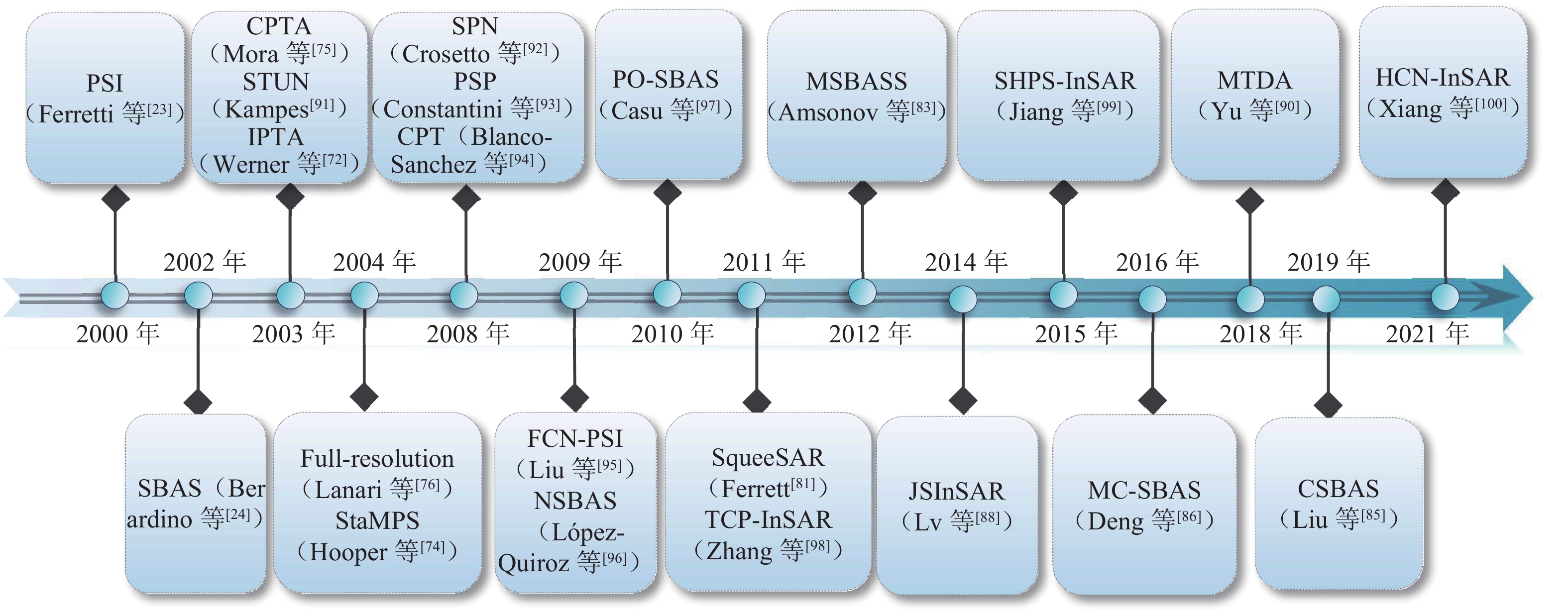
图 3 近20年时序InSAR技术发展图
Figure 3. Development of time-series InSAR technology over past 20 years
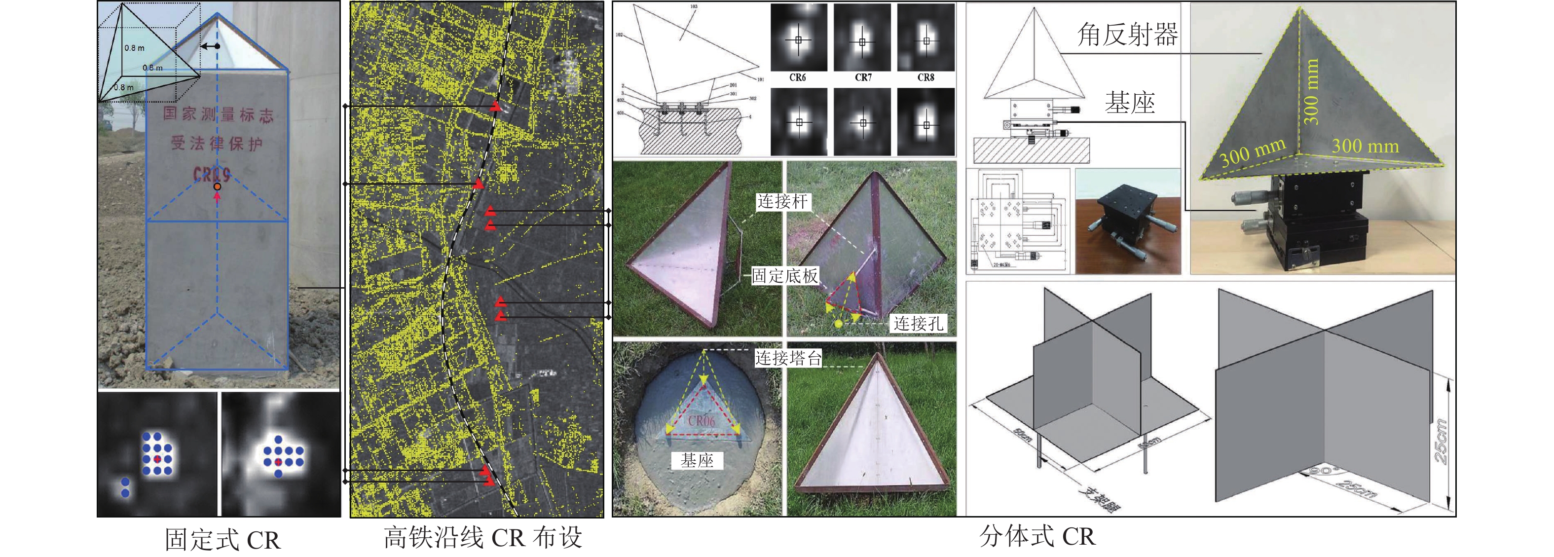
图 4 面向高铁沿线形变监测的角反射器设计与布设
Figure 4. Design and layout of corner reflectors for deformation monitoring along high-speed railways
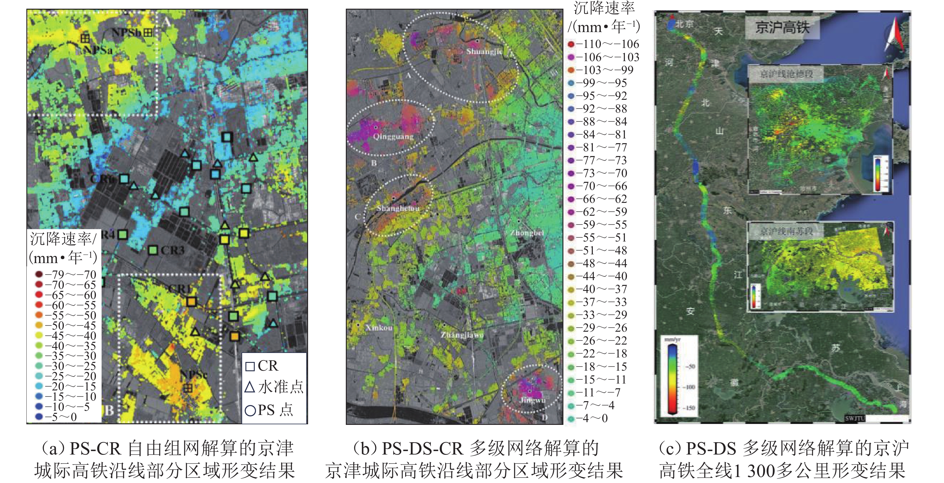
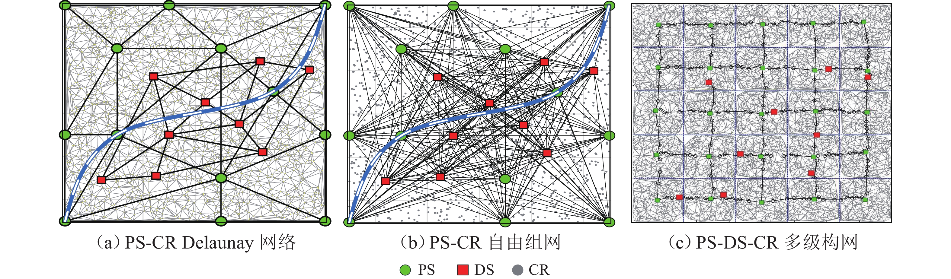
图 6 基于PS-DS-CR构网的高铁沿线形变监测
Figure 6. Deformation monitoring along high-speed railways based on PS-DS-CR network
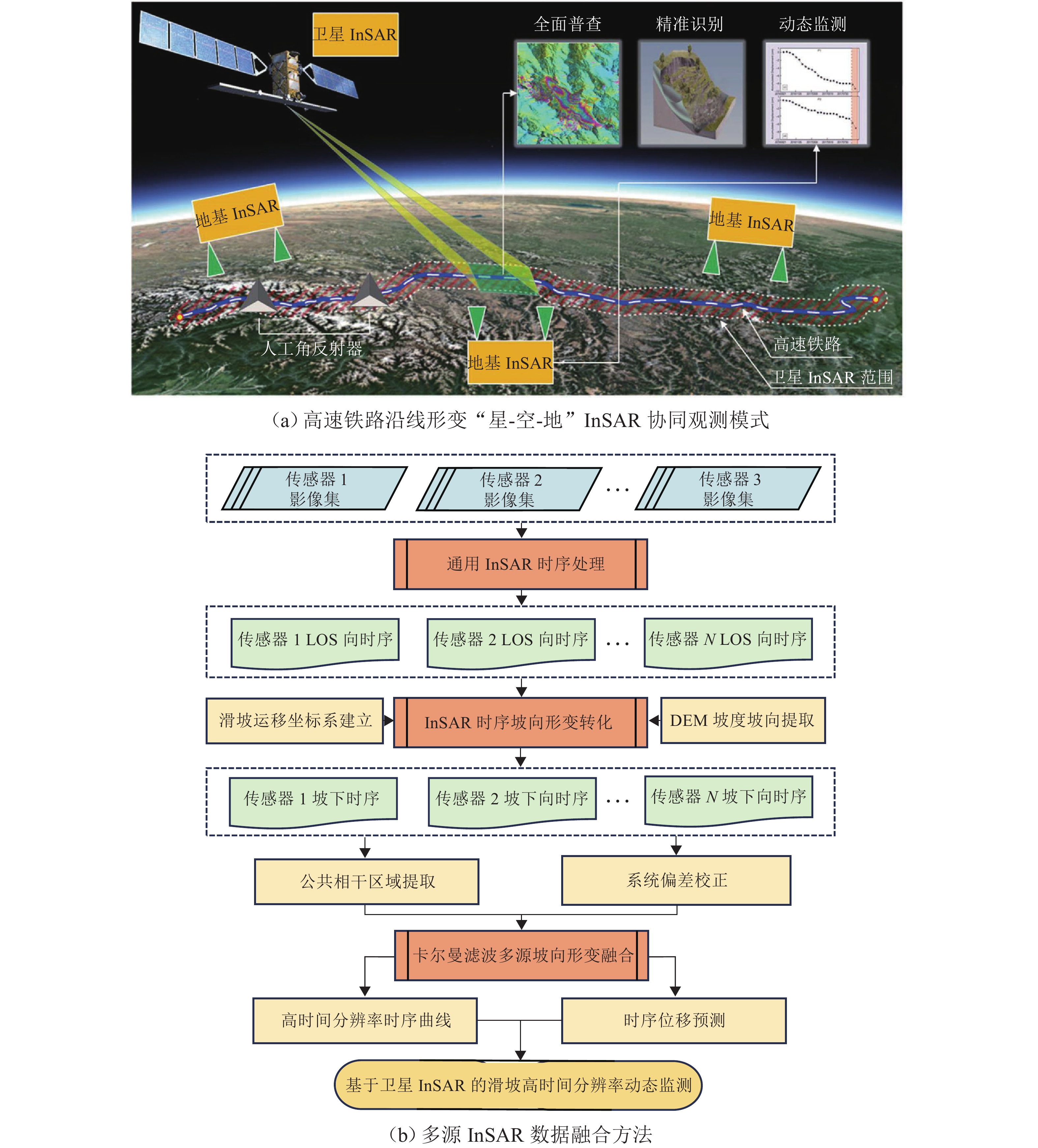
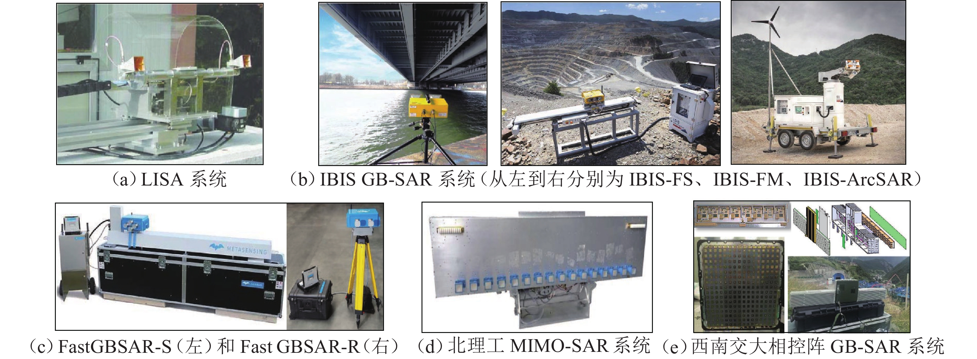
图 9 “星-空-地”InSAR协同观测模式与多平台InSAR数据融合方法
Figure 9. “Space-air-ground” InSAR collaborative observation mode and multi-platform InSAR data fusion method
表 1 现役主要SAR卫星系统参数
Table 1. Parameters of active main SAR satellite systems
卫星名称 发射年份 波段 轨道重访/d 测绘幅宽/km 距离向带宽/MHz 入射角范围/(°) TerraSAR-X 2007 X 11 10~100 150 (最大 300) 15~60 RADARSAT-2 2007 C 24 20~500 100 (最大) 20~50 TanDEM-X 2010 X 11 10~100 150 (最大 300) 15~60 Sentinel-1 (A/C/D) 2014/2024/2025 C 6 (星座) 80~400 100 (最大) 20~46 ALOS-2 2014 L 14 25~490 14~84 8~70 GF-3 (01/02/03) 2016/2021/2022 C 29 10~650 240 (最大) 10~60 ICEYE 2018 X 小时级 5~30 300~600 15~45 SAOCOM-1(A/B) 2018/2020 L 16 40~350 50 (最大) 17~50 RCM 2019 C 4 (星座) 20~500 100 (最大) 14~50 CSG (二代CSK) 2019/2022/2024 X 16 10~200 1200 (最大)20~60 Capella 2020 X 小时级 5~10 500~700 15~45 LT-1 (A/B) 2022 L 4/8 50~400 80 10~60 LT-4 2023 L 1 400~ 1000 +ALOS-4 2024 L 14 200~700 84 (最大) 8~70 NISAR 2025 L/S 12 >240 80(L)/40(S) 34~48 BIOMASS 2025 P 3 45~150 6 23~35  下载: 导出CSV
表 2 常见InSAR多维形变监测方法对比
Table 2. Comparison of common InSAR multi-dimensional deformation monitoring methods
方法类型 主要数据源 计算形变维度 主要优点 主要局限 单轨 InSAR 单一轨道 SAR(C/L/X 波段) LOS 一维 数据量少、数据处理时间短 仅 LOS 分量,难反映真实运动方向 升降轨 InSAR 升轨 + 降轨 SAR 垂直 + 东西向(准 3D) 无需外业数据、适合廊道连续监测 南北向不敏感 多入射角/多平台 InSAR 不同平台/波段/模式 SAR 垂直 + 水平(增强可观测性) 相干性互补、适应大范围复杂地表 跨平台基准统一复杂、处理流程繁琐 InSAR + GNSS InSAR + GNSS 连续站 三维位移/速度场 三维解算物理意义明确、基准稳定 GNSS 点稀疏、外业成本高 InSAR + 水准 InSAR + 精密水准 水平 + 垂直位移(高精度) 垂直精度高、工程认可度高 水平分量可靠性低 单轨 InSAR + MAI 单一轨道 SAR(C/L/X 波段) LOS + 沿轨向(AT) 可补南北向分量、增强准 3D 监测能力 对相干性敏感 单轨 InSAR + POT 单一轨道SAR(C/L/X 波段) 平面位移(低精度) 适用于大位移和低相干区 精度低 单轨 InSAR + MAI + POT 单一轨道 SAR(C/L/X 波段) 准三维(LOS+AT+ 平面) 多尺度互补、缓变和突变兼顾 流程复杂、误差传播难控制 多源 InSAR + MAI 不同平台/波段 SAR 三维形变场 维度完整、工程解释性强 数据量大,计算效率低;对相干性敏感 多源 InSAR + POT 不同平台/波段 SAR 三维形变场 维度完整、适应于大梯度和低相干区形变 精度低 多源 InSAR + MAI + POT 不同平台/波段 SAR 三维形变场 维度完整、兼顾形变精度和场景复杂性 涉及3种技术,数据处理效率低
下载: 导出CSV
表 3 高速铁路沿线地质灾害InSAR监测关键技术不同场景适用性、作用、优势及解决的工程痛点对比
Table 3. Comparison of applicability, functions, advantages, and solved engineering pain points of key technologies for InSAR monitoring of geological hazards along high-speed railways in different scenarios
场景 项目 人工角反射器(CR) 多级目标构网 多维形变解算 “星-空-地”协同监测 平原沉降区 适用性 强 强 较强 强 作用 提供稳定基准,抑制误差累积,适配线性廊道,可与水准/GNSS 交叉验证 兼顾长大线路覆盖与精度,分层解算提升效率,抑制各类误差累积 获取垂直向沉降和水平向微小位移,助力形变机理解译,弥补 LOS 向监测局限 星载普查 + 机载详查 + 地面精查,实现平原沉降全域高精度监测 山区滑坡区 适用性 强 强 强 强 作用 弥补滑坡区自然相干点不足,捕捉关键部位形变,提升监测可靠性 适配滑坡体散射体不均特点,提升监测点密度,保障形变场连续性 解算滑坡体三维形变,精准判断滑坡滑动方向、速率及稳定性 突破山区地形限制,多平台互补,精准捕捉滑坡边界与动态演化 桥隧重点段 适用性 强 较强 强 强 作用 相位中心稳定,实现构筑物毫米级精准监测 分级构网聚焦关键断面,筛选高质量目标点,提升病害定位精度 解算桥隧三维形变,精准识别结构病害,支撑安全评估 宏观把控 + 微观精细监测,适配桥隧结构精细化运维需求 植被/农田弱相干区 适用性 强 强 一般 强 作用 提供强散射源,解决时空去相干问题,保障监测连续性 联合 CR/DS 弥补相干点稀疏缺陷,实现弱相干区连续监测 实现有限三维形变解算,降低噪声干扰 机载/地面 SAR 弥补星载穿透弱短板,减少弱相干区监测盲区 临灾预警 适用性 较强 较强 强 强 作用 提供高精度先验点位,辅助捕捉临灾微小形变,支撑预警核验 快速筛选高稳定性目标点,获取异常形变,提升预警效率 捕捉三维形变突变特征,研判破坏前兆,弥补 LOS 向误判风险 实现实时监测,突破星载重访局限,形成预警闭环 技术核心优势与解决的工程痛点 提供稳定强散射体,突破地表覆被限制,解决自然相干点稀疏及缺少绝对形变基准等问题 兼顾监测精度与覆盖率,解决大尺度/长距离监测的误差累积,连接孤立形变区 突破单 LOS 盲区,还原真实运动矢量,解决复杂坡体滑移、断层错动等具有显著水平运动特征的形变低估与误判 实现宏观普查、局部详查与微观精查的跨模态融合,弥补星载 InSAR 重访周期长、极高植被穿透弱等短板
下载: 导出CSV
-
[1] 国家发展和改革委员会. 国家综合立体交通网规划纲要(2021—2035年)[R]. 北京: 国家发展和改革委员会, 2021. [2] 中国国家铁路集团有限公司. 2023年铁路统计公报[R]. 北京: 中国国家铁路集团有限公司, 2024. [3] International Union of Railways (UIC). High-speed rail atlas 2024[R]. Paris: International Union of Railways, 2024. [4] 李佳洺, 王姣娥. 建立服务新发展格局的内通外联网络化国土空间格局[J]. 中国科学院院刊, 2024, 39(4): 702-713. doi: 10.16418/j.issn.1000-3045.20240319005LI Jiaming, WANG Jiaoe. Establishing networked territorial spatial pattern to serve new development pattern[J]. Bulletin of Chinese Academy of Sciences, 2024, 39(4): 702-713. doi: 10.16418/j.issn.1000-3045.20240319005 [5] 孙琪皓, 刘桂卫, 王飞, 等. 铁路地质灾害早期识别与监测预警技术及应用研究[J]. 铁道标准设计, 2024, 68(9): 24-31. doi: 10.13238/j.issn.1004-2954.202302100005 [6] 向鹏成, 杨斯迈, 袁永奇. 西部区域重大交通基础设施互联互通协同发展的挑战与推进路径[J]. 重庆大学学报(社会科学版), 2024, 30(6): 26-40. doi: 10.11835/j.issn.1008-5831.jg.2024.09.010XIANG Pengcheng, YANG Simai, YUAN Yongqi. Challenges and paths to coordinated development of regional mega-transportation infrastructure interconnection in the western region[J]. Journal of Chongqing University (Social Science Edition), 2024, 30(6): 26-40. doi: 10.11835/j.issn.1008-5831.jg.2024.09.010 [7] BANISTER D. High-speed rail in global transport policy: a critical review[J]. Journal of Transport Policy and Planning, 2019, 26(3): 241-256. [8] ZHENG Q, LYU H M, ZHOU A N, et al. Risk assessment of geohazards along Cheng—Kun railway using fuzzy AHP incorporated into GIS[J]. Geomatics, Natural Hazards and Risk, 2021, 12(1): 1508-1531. doi: 10.1080/19475705.2021.1933614 [9] ZHOU S H, WANG B L, SHAN Y. Review of research on high-speed railway subgrade settlement in soft soil area[J]. Railway Engineering Science, 2020, 28(2): 129-145. doi: 10.1007/s40534-020-00214-x [10] ZHANG Y, WEI L H, LI J Y, et al. Subsidence evaluation of high-speed railway in Shenyang based on time-series InSAR[J]. ISPRS Annals of the Photogrammetry, Remote Sensing and Spatial Information Sciences, 2018, 4: 273-276. doi: 10.5194/isprs-annals-iv-3-273-2018 [11] 国家铁路局. 高速铁路运营安全管理办法[S]. 北京: 国家铁路局, 2022. [12] 张冠军. 高速铁路运营监测技术综述与展望[J]. 铁道勘察, 2023, 49(1): 7-11. doi: 10.19630/j.cnki.tdkc.202210200001ZHANG Guanjun. Overview and prospect of high-speed railway operation monitoring technology[J]. Railway Investigation and Surveying, 2023, 49(1): 7-11. doi: 10.19630/j.cnki.tdkc.202210200001 [13] 强小俊. 北斗定位技术在高速铁路沉降变形监测中的应用[J]. 铁道建筑, 2020, 60(7): 81-84.QIANG Xiaojun. Application of Beidou positioning technology in settlement monitoring of high speed railway[J]. Railway Engineering, 2020, 60(7): 81-84. [14] SU M X, CHENG K, LIU Y M, et al. Combining geophysical methods, drilling, and monitoring techniques to investigate carbonaceous shale landslides along a railway line: a case study on Jiheng Railway, China[J]. Bulletin of Engineering Geology and the Environment, 2021, 80(10): 7493-7506. doi: 10.1007/s10064-021-02365-5 [15] 杜亚宇, 王瑞, 包云, 等. 高速铁路灾害监测系统智能化联调联试平台研究[J]. 铁路计算机应用, 2019, 28(2): 41-44. doi: 10.3969/j.issn.1005-8451.2019.02.010DU Yayu, WANG Rui, BAO Yun, et al. Intelligent commissioning and integrated testing platform for high-speed railway disaster monitoring system[J]. Railway Computer Application, 2019, 28(2): 41-44. doi: 10.3969/j.issn.1005-8451.2019.02.010 [16] MASSONNET D, FEIGL K L. Radar interferometry and its application to changes in the Earth’s surface[J]. Reviews of Geophysics, 1998, 36(4): 441-500. doi: 10.1029/97RG03139 [17] ROSEN P A, HENSLEY S, JOUGHIN I R, et al. Synthetic aperture radar interferometry[J]. Proceedings of the IEEE, 2000, 88(3): 333-382. doi: 10.1109/5.838084 [18] 许才军, 何平, 温扬茂, 等. InSAR技术及应用研究进展[J]. 测绘地理信息, 2015, 40(2): 1-9.XU Caijun, HE Ping, WEN Yangmao, et al. Recent advances in SAR interferometry and its applications[J]. Journal of Geomatics, 2015, 40(2): 1-9. [19] ZEBKER H A, VILLASENOR J. Decorrelation in interferometric radar echoes[J]. IEEE Transactions on Geoscience and Remote Sensing, 1992, 30(5): 950-959. doi: 10.1109/36.175330 [20] CURLANDER J C, MCDONOUGH R N. Synthetic aperture radar[M]. New York: Wiley, 1991. [21] WANG R, YANG M S, DONG J, et al. Investigating deformation along metro lines in coastal cities considering different structures with InSAR and SBM analyses[J]. International Journal of Applied Earth Observation and Geoinformation, 2022, 115: 103099. doi: 10.1016/j.jag.2022.103099 [22] CHEN Y, ZHANG G, DING X, et al. Monitoring earth surface deformations with InSAR technology: principles and some critical issues[J]. Journal of Geospatial Engineering, 2000, 2(1): 3-22. [23] FERRETTI A, PRATI C, ROCCA F. Permanent scatterers in SAR interferometry[J]. IEEE Transactions on Geoscience and Remote Sensing, 2001, 39(1): 8-20. doi: 10.1109/36.898661 [24] BERARDINO P, FORNARO G, LANARI R, et al. A new algorithm for surface deformation monitoring based on small baseline differential SAR interferograms[J]. IEEE Transactions on Geoscience and Remote Sensing, 2002, 40(11): 2375-2383. doi: 10.1109/TGRS.2002.803792 [25] SHI M, CHEN B B, GONG H L, et al. Monitoring differential subsidence along the Beijing—Tianjin intercity railway with multiband SAR data[J]. International Journal of Environmental Research and Public Health, 2019, 16(22): 4453. doi: 10.3390/ijerph16224453 [26] SHI X G, JIANG L M, JIANG H J, et al. Geohazards analysis of the Litang—Batang section of Sichuan—Tibet railway using SAR interferometry[J]. IEEE Journal of Selected Topics in Applied Earth Observations and Remote Sensing, 2021, 14: 11998-12006. doi: 10.1109/JSTARS.2021.3129270 [27] KURAS P, ORTYL Ł, OWERKO T, et al. GB-SAR in the diagnosis of critical city infrastructure: a case study of a load test on the long tram extradosed bridge[J]. Remote Sensing, 2020, 12(20): 3361. doi: 10.3390/rs12203361 [28] 张志华, 胡长涛, 张镇, 等. 基于PS-InSAR上海地区地表沉降监测与分析[J]. 自然资源遥感, 2022, 34(3): 106-111.ZHANG Zhihua, HU Changtao, ZHANG Zhen, et al. PS-InSAR-based monitoring and analysis of surface subsidence in Shanghai[J]. Remote Sensing for Natural Resources, 2022, 34(3): 106-111. [29] ZHANG Q Y, LI Y S, ZHANG J F, et al. InSAR technique applied to the monitoring of the Qinghai–Tibet Railway[J]. Natural Hazards and Earth System Sciences, 2019, 19(10): 2229-2240. doi: 10.5194/nhess-19-2229-2019 [30] HU F M, VAN LEIJEN F J, CHANG L, et al. Monitoring deformation along railway systems combining multi-temporal InSAR and LiDAR data[J]. Remote Sensing, 2019, 11(19): 2298. doi: 10.3390/rs11192298 [31] KIZILIRMAK G, CAKIR Z. Application of PS-InSAR and diagnostic train measurement techniques for monitoring subsidence in high-speed railway in Konya, türkiye[J]. Infrastructures, 2024, 9(9): 152. doi: 10.3390/infrastructures9090152 [32] CASTILLO-MINGORANCE J M, SOL-SÁNCHEZ M, MORENO-NAVARRO F, et al. A critical review of sensors for the continuous monitoring of smart and sustainable railway infrastructures[J]. Sustainability, 2020, 12(22): 9428. doi: 10.3390/su12229428 [33] SUN J W, YUAN G Q, SONG L Y, et al. Unmanned aerial vehicles (UAVs) in landslide investigation and monitoring: a review[J]. Drones, 2024, 8(1): 30. doi: 10.3390/drones8010030 [34] DU Z, LIU F, YANG J, et al. Integrating low-altitude SAR imaging into UAV data backhaul[EB/OL]. (2025-12-26)[2026-01-04]. https://arxiv.org/abs/2512.21937. [35] 王军锋, 乔明, 魏育成, 等. 无人机机载 SAR 在地理国情监测中的应用研究[J]. 测绘与空间地理信息, 2016, 39(5): 61-64. doi: 10.3969/j.issn.1672-5867.2016.05.018WANG Junfeng, QIAO Ming, WEI Yucheng, et al. Geographical situation monitoring applications based on the UAV airborne SAR[J]. Geomatics & Spatial Information Technology, 2016, 39(5): 61-64. doi: 10.3969/j.issn.1672-5867.2016.05.018 [36] VALENTINA C M. Geological structures extraction from slope instabilities using GB-SAR data[D]. Padova: Università degli Studi di Padova, 2023. [37] WANG C, ZHOU L, MA J, et al. GB-RAR deformation information estimation of high-speed railway bridge in consideration of the effects of colored noise[J]. Applied Sciences, 2022, 12(20): 10504. doi: 10.3390/app122010504 [38] 周志伟, 程翔, 周伟, 等. 地基SAR在滑坡形变监测中的应用[J]. 测绘通报, 2022(7): 60-63.ZHOU Zhiwei, CHENG Xiang, ZHOU Wei, et al. Application of ground SAR in landslide deformation monitoring[J]. Bulletin of Surveying and Mapping, 2022(7): 60-63. [39] THOMPSON T W, WEISSMAN D E, GONZALEZ F I. L band radar backscatter dependence upon surface wind stress: a Summary of new SEASAT-1 and aircraft observations[J]. Journal of Geophysical Research: Oceans, 1983, 88(3): 1727-1735. doi: 10.1029/jc088ic03p01727 [40] CIMINO J, ELACHI C, SETTLE M. SIR-B-the second shuttle imaging radar experiment[J]. IEEE Transactions on Geoscience and Remote Sensing, 1986, 24(4): 445-452. doi: 10.1109/tgrs.1986.289658 [41] 朱建军, 李志伟, 胡俊. InSAR变形监测方法与研究进展[J]. 测绘学报, 2017, 46(10): 1717-1733. doi: 10.11947/j.AGCS.2017.20170350ZHU Jianjun, LI Zhiwei, HU Jun. Research progress and methods of InSAR for deformation monitoring[J]. Acta Geodaetica et Cartographica Sinica, 2017, 46(10): 1717-1733. doi: 10.11947/j.AGCS.2017.20170350 [42] VAN ZYL J J. The Shuttle Radar Topography Mission (SRTM): a breakthrough in remote sensing of topography[J]. Acta Astronautica, 2001, 48(5/6/7/8/9/10/11/12): 559-565. [43] WERNINGHAUS R, BUCKREUSS S. The TerraSAR-X mission and system design[J]. IEEE Transactions on Geoscience and Remote Sensing, 2010, 48(2): 606-614. doi: 10.1109/TGRS.2009.2031062 [44] BUCKREUSS S, ZINK M. TerraSAR-X and TanDEM-X mission status[C]//Proceedings of EUSAR 2016: 11th European Conference on Synthetic Aperture Radar. Hamburg: VDE, 2016: 1-6. [45] META A, MITTERMAYER J, PRATS P, et al. TOPS imaging with TerraSAR-X: mode design and performance analysis[J]. IEEE Transactions on Geoscience and Remote Sensing, 2010, 48(2): 759-769. doi: 10.1109/TGRS.2009.2026743 [46] SACCO P, BATTAGLIERE M L, COLETTA A. COSMO-SkyMed mission status: results, lessons learnt and evolutions[C]//2015 IEEE International Geoscience and Remote Sensing Symposium (IGARSS). Piscataway: IEEE, 2015: 207-210. [47] POTIN P, ROSICH B, GRIMONT P, et al. Sentinel-1 mission status[C]//Proceedings of EUSAR 2016: 11th European Conference on Synthetic Aperture Radar. Hamburg: VDE, 2016: 1-6. [48] D’ERRICO M. Evolution of spaceborne SAR missions in earth orbit[J]. Remote Sensing, 2025, 17(22): 1-6. doi: 10.3390/rs17223773 [49] MOTOHKA T, KANKAKU Y, MIURA S, et al. ALOS-4 L-band SAR observation concept and development status[C]//IGARSS 2020—2020 IEEE International Geoscience and Remote Sensing Symposium. Piscataway: IEEE, 2021: 3792-3794. [50] The load design and implementation of HJ-1-C space-borne SAR[J]. Journal of Radars, 2014, 3(3): 256-265. [51] 张庆君. 高分三号卫星总体设计与关键技术[J]. 测绘学报, 2017, 46(3): 269-277.ZHANG Qingjun. System design and key technologies of the GF-3 satellite[J]. Acta Geodaetica et Cartographica Sinica, 2017, 46(3): 269-277. [52] ZHANG G, WANG S Y, CHEN Z W, et al. Development of China’s spaceborne SAR satellite, processing strategy, and application: take Gaofen-3 series as an example[J]. Geo-Spatial Information Science, 2024, 27(1): 221-236. doi: 10.1080/10095020.2022.2124129 [53] 谢婷, 王怡人, 吕素娜, 等. 海丝一号卫星及其应用展望[J]. 卫星应用, 2021(10): 40-44. [54] 范季夏. 高分辨率SAR卫星技术现状及发展展望[J]. 上海航天(中英文), 2024, 41(增1): 19-33. doi: 10.19328/j.cnki.2096-8655.2024.S1.003FAN Jixia. Current status and development trends of high resolution spaceborne SAR satellite[J]. Aerospace Shanghai (Chinese & English), 2024, 41(S1): 19-33. doi: 10.19328/j.cnki.2096-8655.2024.S1.003 [55] HELD D N, BROWN W E, FREEMAN A, et al. The NASA/JPL multifrequency, multipolarisation airborne SAR system[C]//International Geoscience and Remote Sensing Symposium, Remote Sensing: Moving Toward the 21st Century. Piscataway: IEEE, 2002: 345-349. [56] ROSEN P A, HENSLEY S, WHEELER K, et al. UAVSAR: a new NASA airborne SAR system for science and technology research[C]//2006 IEEE Conference on Radar. Piscataway: IEEE, 2006: 22-29. [57] SVEDIN J, BERNLAND A, GUSTAFSSON A, et al. Small UAV-based SAR system using low-cost radar, position, and attitude sensors with onboard imaging capability[J]. International Journal of Microwave and Wireless Technologies, 2021, 13(6): 602-613. doi: 10.1017/S1759078721000416 [58] MOREIRA A, PRATS-IRAOLA P, YOUNIS M, et al. A tutorial on synthetic aperture radar[J]. IEEE Geoscience and Remote Sensing Magazine, 2013, 1(1): 6-43. doi: 10.1109/MGRS.2013.2248301 [59] LIVINGSTONE C E, GRAY A L, HAWKINS R K, et al. CCRS C/X-airborne synthetic aperture radar: an R and D tool for the ERS-1 time frame[J]. IEEE Aerospace and Electronic Systems Magazine, 1988, 3(10): 11-20. doi: 10.1109/nrc.1988.10923 [60] DREUILLET P, CANTALLOUBE H, COLIN E, et al. The ONERA RAMSES SAR: latest significant results and future developments[C]//2006 IEEE Conference on Radar. Piscataway: IEEE, 2006: 1631849. [61] ANGÉLLIAUME S, DUBOIS-FERNANDEZ P, DREUILLET P, et al. SETHI, the ONERA airborne SAR sensor, and his low frequency capability[C]//2009 IEEE International Geoscience and Remote Sensing Symposium. Piscataway: IEEE, 2010: 179. [62] 周良将, 汪丙南, 王亚超, 等. 机载多维度SAR航空观测系统实验初步进展[J]. 电子与信息学报, 2023, 45(4): 1243-1253. doi: 10.11999/JEIT220250ZHOU Liangjiang, WANG Bingnan, WANG Yachao, et al. Preliminary process of airborne multidimensional space joint-observation SAR system[J]. Journal of Electronics & Information Technology, 2023, 45(4): 1243-1253. doi: 10.11999/JEIT220250 [63] RUDOLF H, LEVA D, TARCHI D, et al. A mobile and versatile SAR system[C]//IEEE 1999 International Geoscience and Remote Sensing Symposium. IGARSS’99. Piscataway: IEEE, 2002: 592-594. [64] WANG Y P, HONG W, ZHANG Y, et al. Ground-based differential interferometry SAR: a review[J]. IEEE Geoscience and Remote Sensing Magazine, 2020, 8(1): 43-70. doi: 10.1109/MGRS.2019.2963169 [65] PIERACCINI M, MICCINESI L. Ground-based radar interferometry: a bibliographic review[J]. Remote Sensing, 2019, 11(9): 1029. doi: 10.3390/rs11091029 [66] MONSERRAT O, CROSETTO M, LUZI G. A review of ground-based SAR interferometry for deformation measurement[J]. ISPRS Journal of Photogrammetry and Remote Sensing, 2014, 93: 40-48. doi: 10.1016/j.isprsjprs.2014.04.001 [67] 刘龙龙, 张继贤, 赵争, 等. GB-SAR变形监测技术研究现状与展望[J]. 测绘通报, 2019(11): 1-7.LIU Longlong, ZHANG Jixian, ZHAO Zheng, et al. Research status and prospects of GB-SAR deformation monitoring technology[J]. Bulletin of Surveying and Mapping, 2019(11): 1-7. [68] DAN Q H, YU C R, HUANG S S, et al. Ground-based MIMO-SAR fast imaging algorithm based on geometric transformation[J]. Electronics, 2023, 12(6): 1466. doi: 10.3390/electronics12061466 [69] 谭恺, 吴世有, 王友成, 等. 用于超宽带高分辨率成像的二维稀疏MIMO面阵拓扑结构研究[J]. 电波科学学报, 2016, 31(4): 779-785. doi: 10.13443/j.cjors.2015121701TAN Kai, WU Shiyou, WANG Youcheng, et al. Two-dimensional sparse MIMO array topologies for UWB high-resolution imaging[J]. Chinese Journal of Radio Science, 2016, 31(4): 779-785. doi: 10.13443/j.cjors.2015121701 [70] 黄平平, 李凯, 徐伟, 等. 基于隐函数导数法的双基弧形阵列SAR二维频谱及成像算法[J]. 信号处理, 2021, 37(4): 496-506. doi: 10.16798/j.issn.1003-0530.2021.04.003HUANG Pingping, LI Kai, XU Wei, et al. A two-dimensional spectrum and imaging algorithm for arc array bistatic SAR using derivatives of an implicit function[J]. Journal of Signal Processing, 2021, 37(4): 496-506. doi: 10.16798/j.issn.1003-0530.2021.04.003 [71] LEE H, JI Y, HAN H. Experiments on a ground-based tomographic synthetic aperture radar[J]. Remote Sensing, 2016, 8(8): 667. doi: 10.3390/rs8080667 [72] WERNER C, WEGMULLER U, STROZZI T, et al. Interferometric point target analysis for deformation mapping[C]//IGARSS 2003.2003 IEEE International Geoscience and Remote Sensing Symposium. Proceedings. Piscataway: IEEE, 2004: 4362-4364. [73] KAMPES B M. Radar interferometry: persistent scatterer technique[M]. Dordrecht: Springer Netherlands, 2006. [74] HOOPER A, ZEBKER H, SEGALL P, et al. A new method for measuring deformation on volcanoes and other natural terrains using InSAR persistent scatterers[J]. Geophysical Research Letters, 2004, 31(23): 23611. doi: 10.1029/2004gl021737 [75] MORA O, MALLORQUI J J, BROQUETAS A. Linear and nonlinear terrain deformation maps from a reduced set of interferometric SAR images[J]. IEEE Transactions on Geoscience and Remote Sensing, 2003, 41(10): 2243-2253. doi: 10.1109/TGRS.2003.814657 [76] LANARI R, MORA O, MANUNTA M, et al. A small-baseline approach for investigating deformations on full-resolution differential SAR interferograms[J]. IEEE Transactions on Geoscience and Remote Sensing, 2004, 42(7): 1377-1386. doi: 10.1109/TGRS.2004.828196 [77] BLANCO-SÁNCHEZ P, MALLORQUÍ J J, DUQUE S, et al. The coherent pixels technique (CPT): an advanced DInSAR technique for nonlinear deformation monitoring[J]. Pure and Applied Geophysics, 2008, 165(6): 1167-1193. doi: 10.1007/978-3-7643-8907-9_10 [78] CROSETTO M, CRIPPA B, BIESCAS E. Early detection and in-depth analysis of deformation phenomena by radar interferometry[J]. Engineering Geology, 2005, 79(1/2): 81-91. doi: 10.1016/j.enggeo.2004.10.016 [79] COSTANTINI M. A novel phase unwrapping method based on network programming[J]. IEEE Transactions on Geoscience and Remote Sensing, 1998, 36(3): 813-821. doi: 10.1109/36.673674 [80] LIU G X, JIA H G, ZHANG R, et al. Subsidence detection by PSInSAR based on high resolution TerraSAR-X images[C]//Progress in Electromagnetics Research Symposium Proceedings. Xi’an: The Electromagnetics Academy, 2010: 11-15. [81] FERRETTI A, FUMAGALLI A, NOVALI F, et al. A new algorithm for processing interferometric data-stacks: SqueeSAR[J]. IEEE Transactions on Geoscience and Remote Sensing, 2011, 49(9): 3460-3470. doi: 10.1109/TGRS.2011.2124465 [82] CASU F, ELEFANTE S, IMPERATORE P, et al. SBAS-DInSAR parallel processing for deformation time-series computation[J]. IEEE Journal of Selected Topics in Applied Earth Observations and Remote Sensing, 2014, 7(8): 3285-3296. doi: 10.1109/JSTARS.2014.2322671 [83] SAMSONOV S, D’OREYE N. Multidimensional time-series analysis of ground deformation from multiple InSAR data sets applied to Virunga Volcanic Province[J]. Geophysical Journal International, 2012, 191(3): 1095-1108. doi: 10.1111/j.1365-246x.2012.05669.x [84] DOIN M P, LODGE F, GUILLASO S, et al. Presentation of the small baseline NSBAS processing chain on a case example: the Etna deformation monitoring from 2003 to 2010 using Envisat data[C]//Proceedings of the Fringe Symposium. Frascati: ESA, 2011: 3434-3437. [85] LIU Y Y, ZHAO C Y, ZHANG Q, et al. A constrained small baseline subsets (CSBAS) InSAR technique for multiple subsets[J]. European Journal of Remote Sensing, 2020, 53(1): 14-26. doi: 10.1080/22797254.2019.1707715 [86] 邓琳, 刘国祥, 张瑞, 等. 多平台MC-SBAS长时序建模与形变提取方法[J]. 测绘学报, 2016, 45(2): 213-223.DENG Lin, LIU Guoxiang, ZHANG Rui, et al. A multi-platform MC-SBAS method for extracting long-term ground deformation[J]. Acta Geodaetica et Cartographica Sinica, 2016, 45(2): 213-223. [87] ZHANG L, DING X L, LU Z. Modeling PSInSAR time series without phase unwrapping[J]. IEEE Transactions on Geoscience and Remote Sensing, 2011, 49(1): 547-556. doi: 10.1109/TGRS.2010.2052625 [88] LV X L, YAZıCı B, ZEGHAL M, et al. Joint-scatterer processing for time-series InSAR[J]. IEEE Transactions on Geoscience and Remote Sensing, 2014, 52(11): 7205-7221. doi: 10.1109/TGRS.2014.2309346 [89] 蒋弥, 丁晓利, 李志伟. 时序InSAR同质样本选取算法研究[J]. 地球物理学报, 2018, 61(12): 4767-4776. doi: 10.6038/cjg2018L0490JIANG Mi, DING Xiaoli, LI Zhiwei. Homogeneous pixel selection algorithm for multitemporal InSAR[J]. Chinese Journal of Geophysics, 2018, 61(12): 4767-4776. doi: 10.6038/cjg2018L0490 [90] YU H W, LEE H, YUAN T, et al. A novel method for deformation estimation based on multibaseline InSAR phase unwrapping[J]. IEEE Transactions on Geoscience and Remote Sensing, 2018, 56(9): 5231-5243. doi: 10.1109/TGRS.2018.2812769 [91] KAMPES B M, ADAM N. The STUN algorithm for persistent scatterer interferometry[C]//The 5th International Workshop on Automatic Processing of Finge Patterns. Berlin: Springer, 2005: 1-14. [92] CROSETTO M, BIESCAS E, DURO J, et al. Generation of advanced ERS and envisat interferometric SAR products using the stable point network technique[J]. Photogrammetric Engineering & Remote Sensing, 2008, 74(4): 443-450. [93] COSTANTINI M, FALCO S, MALVARANI F, et al. A new algorithm for processing of persistent scatterers in SAR interferometry[C]//2008 IEEE International Geoscience and Remote Sensing Symposium (IGARSS). Piscataway: IEEE, 2008: 242. [94] BLANCO-SÀNCHEZ P, MALLORQUÍ J J, DUQUE S, et al. The coherent pixels technique (CPT): an advanced DInSAR technique for nonlinear deformation monitoring[M]//Earth sciences and mathematics. Basel: Birkhäuser Basel, 2008: 1167-1193. [95] LIU G X, BUCKLEY S M, DING X L, et al. Estimating spatiotemporal ground deformation with improved permanent-scatterer radar interferometry[J]. IEEE Transactions on Geoscience and Remote Sensing, 2009, 47(8): 2762-2772. [96] LÓPEZ-QUIROZ P, DOIN M P, TUPIN F, et al. Time series analysis of Mexico City subsidence from SAR interferometry: February 2004 to July 2006[J]. IEEE Transactions on Geoscience and Remote Sensing, 2009, 69(1): 1-15. [97] CASU F, MANCONI A, PEPE A, et al. Advances in the generation of deformation time series from SAR data sequences in areas affected by large dynamics[C]//2010 IEEE International Geoscience and Remote Sensing Symposium. Piscata: IEEE, 2010: 2618-2621. [98] ZHANG L, LU Z, DING X L, et al. Mapping ground surface deformation using temporarily coherent point SAR interferometry: Application to Los Angeles Basin[J]. Remote Sensing of Environment, 2012, 117: 429-439. [99] JIANG M, DING X L, HANSSEN R F, et al. Fast statistically homogeneous pixel selection for covariance matrix estimation for multitemporal InSAR[J]. IEEE Transactions on Geoscience and Remote Sensing, 2015, 53(3): 1213-1224. [100] XIANG W, ZHANG R, LIU G X, et al. Saline-soil deformation extraction based on an improved time-series InSAR approach[J]. ISPRS International Journal of Geo-Information, 2021, 10(3): 112. [101] GARTHWAITE M C. On the design of radar corner reflectors for deformation monitoring in multi-frequency InSAR[J]. Remote Sensing, 2017, 9(7): 648. doi: 10.3390/rs9070648 [102] DHEENATHAYALAN P, SMALL D, SCHUBERT A, et al. High-precision positioning of radar scatterers[J]. Journal of Geodesy, 2016, 90(5): 403-422. doi: 10.1007/s00190-015-0883-4 [103] HANSSEN R F. Radar interferometry: data interpretation and error analysis[M]. Dordrecht: Springer Netherlands, 2001. [104] PEPE A, LANARI R. On the extension of the minimum cost flow algorithm for phase unwrapping of multitemporal differential SAR interferograms[J]. IEEE Transactions on Geoscience and Remote Sensing, 2006, 44(9): 2374-2383. doi: 10.1109/TGRS.2006.873207 [105] ALONSO-DÍAZ A, ROQUE D, SOLLA M, et al. Comparative analysis of MT-InSAR algorithms supported by GNSS data and corner reflectors: assessing performance and accuracy[J]. Procedia Computer Science, 2024, 239: 1460-1466. doi: 10.1016/j.procs.2024.06.319 [106] DHEENATHAYALAN P, CUENCA M C, HOOGEBOOM P, et al. Small reflectors for ground motion monitoring with InSAR[J]. IEEE Transactions on Geoscience and Remote Sensing, 2017, 55(12): 6703-6712. doi: 10.1109/TGRS.2017.2731424 [107] 李晓恩, 周亮, 苏奋振, 等. InSAR技术在滑坡灾害中的应用研究进展[J]. 遥感学报, 2021, 25(2): 614-629.LI Xiaoen, ZHOU Liang, SU Fenzhen, et al. Application of InSAR technology in landslide hazard: Progress and prospects[J]. Journal of Remote Sensing, 2021, 25(2): 614-629. [108] 杨魁, 陈楚, 张鑫鑫, 等. InSAR中角反射器的识别策略研究[J]. 城市勘测, 2014(6): 10-13.YANG Kui, CHEN Chu, ZHANG Xinxin, et al. The study of corner reflector identification strategy in InSAR[J]. Urban Geotechnical Investigation & Surveying, 2014(6): 10-13. [109] ZHOU L, WEI B D, MA J, et al. Monitoring and analysis of side-slope deformation along Changgan high-speed railway based on time-series InSAR and BDS techniques[J]. Natural Hazards, 2024, 120(14): 13469-13491. [110] ZHANG R, LIU G X, LI Z L, et al. A hierarchical approach to persistent scatterer network construction and deformation time series estimation[J]. Remote Sensing, 2014, 7(1): 211-228. doi: 10.3390/rs70100211 [111] HOOPER A. A multi-temporal InSAR method incorporating both persistent scatterer and small baseline approaches[J]. Geophysical Research Letters, 2008, 35(16): 2008GL034654. doi: 10.1029/2008GL034654 [112] HOU J X, XU B, LI Z W, et al. Block PS-InSAR ground deformation estimation for large-scale areas based on network adjustment[J]. Journal of Geodesy, 2021, 95(10): 111. [113] SAMSONOV S, TIAMPO K, RUNDLE J, et al. Application of DInSAR-GPS optimization for derivation of fine-scale surface motion maps of southern California[J]. IEEE Transactions on Geoscience and Remote Sensing, 2007, 45(2): 512-521. doi: 10.1109/TGRS.2006.887166 [114] BÜRGMANN R, ROSEN P A, FIELDING E J. Synthetic aperture radar interferometry to measure earth’s surface topography and its deformation[J]. Annual Review of Earth and Planetary Sciences, 2000, 28: 169-209. doi: 10.1146/annurev.earth.28.1.169 [115] HU J, DING X L, LI Z W, et al. Vertical and horizontal displacements of Los Angeles from InSAR and GPS time series analysis: Resolving tectonic and anthropogenic motions[J]. Journal of Geodynamics, 2016, 99: 27-38. doi: 10.1016/j.jog.2016.05.003 [116] WRIGHT T J, PARSONS B E, LU Z. Toward mapping surface deformation in three dimensions using InSAR[J]. Geophysical Research Letters, 2004, 31(1): 2003GL018827. doi: 10.1029/2003GL018827 [117] FIALKO Y, SANDWELL D, SIMONS M, et al. Three-dimensional deformation caused by the Bam, Iran, earthquake and the origin of shallow slip deficit[J]. Nature, 2005, 435(7040): 295-299. doi: 10.1038/nature03425 [118] MICHEL R, AVOUAC J P. Deformation due to the 17 August 1999 Izmit, Turkey, earthquake measured from SPOT images[J]. Journal of Geophysical Research: Solid Earth, 2002, 107(4): ETG2-1-ETG2-6. [119] BECHOR N B D, ZEBKER H A. Measuring two-dimensional movements using a single InSAR pair[J]. Geophysical Research Letters, 2006, 33(16): 2006GL026883. doi: 10.1029/2006GL026883 [120] JUNG H S, LU Z. Theoretical accuracy of along-track displacement measurements from multiple-aperture InSAR[J]. Sensors, 2014, 14(9): 17703-17724. doi: 10.3390/s140917703 [121] WANG X W, LIU G X, YU B, et al. An integrated method based on DInSAR, MAI and displacement gradient tensor for mapping the 3D coseismic deformation field related to the 2011 Tarlay earthquake (Myanmar)[J]. Remote Sensing of Environment, 2015, 170: 388-404. [122] PITER A, HAGHIGHI M H, MOTAGH M. Challenges and opportunities of sentinel-1 InSAR for transport infrastructure monitoring[J]. PFG—Journal of Photogrammetry, Remote Sensing and Geoinformation Science, 2024, 92(5): 609-627. doi: 10.1007/s41064-024-00314-x [123] CAI J L, LIU G X, JIA H G, et al. A new algorithm for landslide dynamic monitoring with high temporal resolution by Kalman filter integration of multiplatform time-series InSAR processing[J]. International Journal of Applied Earth Observation and Geoinformation, 2022, 110: 102812. -

 下载:
下载:

 点击查看大图
计量
- 文章访问数: 437
- HTML全文浏览量: 253
- PDF下载量: 63
- 被引次数: 0