

Voxel-Based Multi-Feature Fusion Modeling Method for Fractured Surrounding Rock in Tunnels
-
摘要:
隧道施工至围岩破碎带时易引发塌方冒顶、突水突泥等地质灾害,为全面提升动态优化设计能力以及多场耦合风险分析的精度与效率,本文提出一种融合多源短距离超前预报数据的破碎围岩建模方法. 首先,基于机器学习算法精准提取掌子面影像、地质雷达图像中的破碎围岩特征信息;然后,结合两类数据所具备的几何特征与语义特征,在同一时空基准框架下完成配准与融合,生成统一的语义点集;最后,构建密集体素网格,并遍历各体素邻域范围内的语义点集,采用反距离权重插值算法构建三维破碎围岩体素模型. 以典型长大深埋隧道为案例开展实验评估,并将体素模型与配准后的加深炮孔数据进行体素化处理及属性对齐对比分析. 结果表明:所建体素模型在破碎风险区域的平均分类准确率为83.31%,非风险区域为82.89%;与炮孔数据在体素尺度的时空分布上具有较高一致性,能够有效地刻画破碎围岩在动态开挖过程中的时空演化特征.
Abstract:Fractured surrounding rock zones encountered during tunnel construction can easily trigger geological hazards such as collapses, roof falls, water inrushes, and mudbursts. To comprehensively improve the accuracy and efficiency of dynamic optimization design and multi-field coupled risk analysis, a modeling method for fractured surrounding rock integrating multi-source short-range advanced geological forecasting data was proposed. Firstly, a machine learning algorithm was employed to accurately extract the feature information of fractured surrounding rock from tunnel face images and ground-penetrating radar images. Secondly, the geometric and semantic features of the two types of data were registered and fused within a unified spatiotemporal reference framework to generate a unified semantic point set. Finally, a dense voxel grid was constructed, and the semantic point sets within the neighborhood of each voxel were traversed to build a three-dimensional fractured surrounding rock voxel model using the inverse distance weighting interpolation algorithm. A typical long and deep-buried tunnel was selected as a case to conduct experimental evaluation, and the voxel model and registered deepened blast hole data were subjected to voxelization processing and attribute alignment comparative analysis. The results indicate that the average classification accuracy of the constructed voxel model is 83.31% in fractured risk zones and 82.89% in non-risk zones; the model demonstrates high consistency with the blast hole data in terms of spatiotemporal distribution at the voxel scale, effectively characterizing the spatiotemporal evolution characteristics of the fractured surrounding rock during the dynamic excavation process.
-
Key words:
- tunnel /
- voxel model /
- machine learning /
- feature fusion /
- spatial interpolation
-
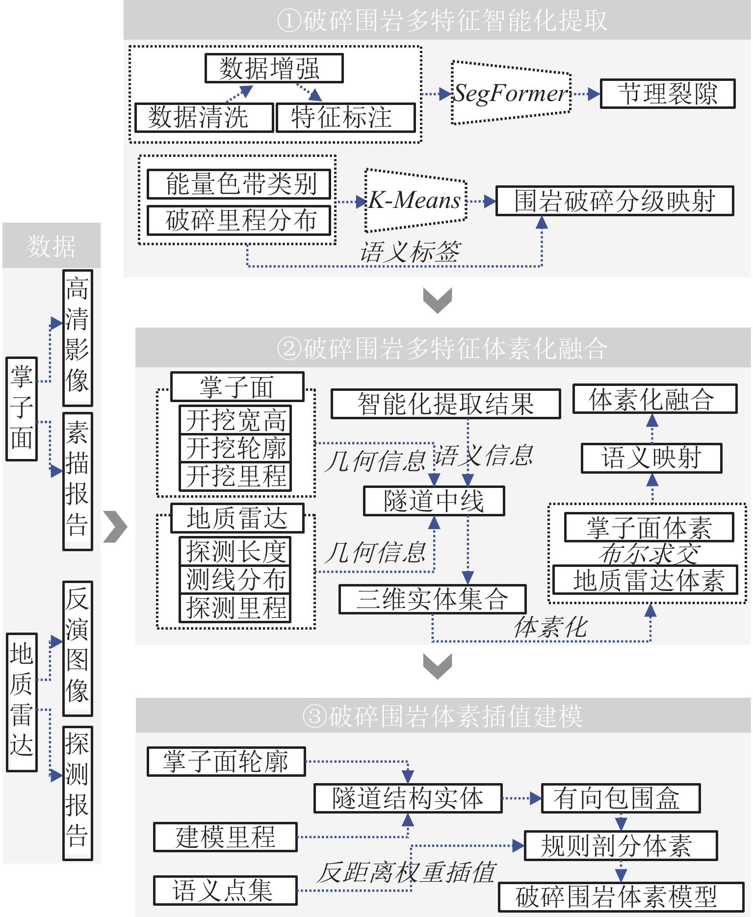
图 1 基于体素的隧道破碎围岩多特征融合建模方法流程
Figure 1. Flowchart of voxel-based multi-feature fusion modeling method for fractured surrounding rock in tunnels
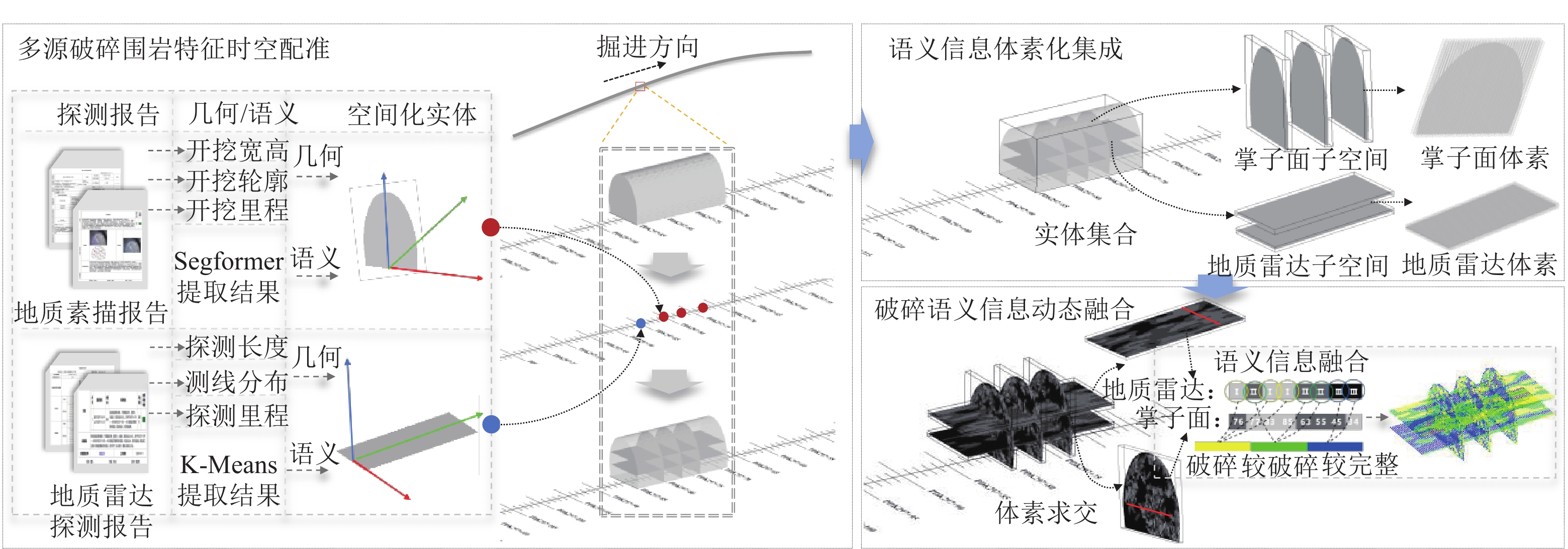
图 3 隧道破碎围岩多特征体素化融合流程图
Figure 3. Flowchart of multi-feature voxelization fusion for fractured surrounding rock in tunnels
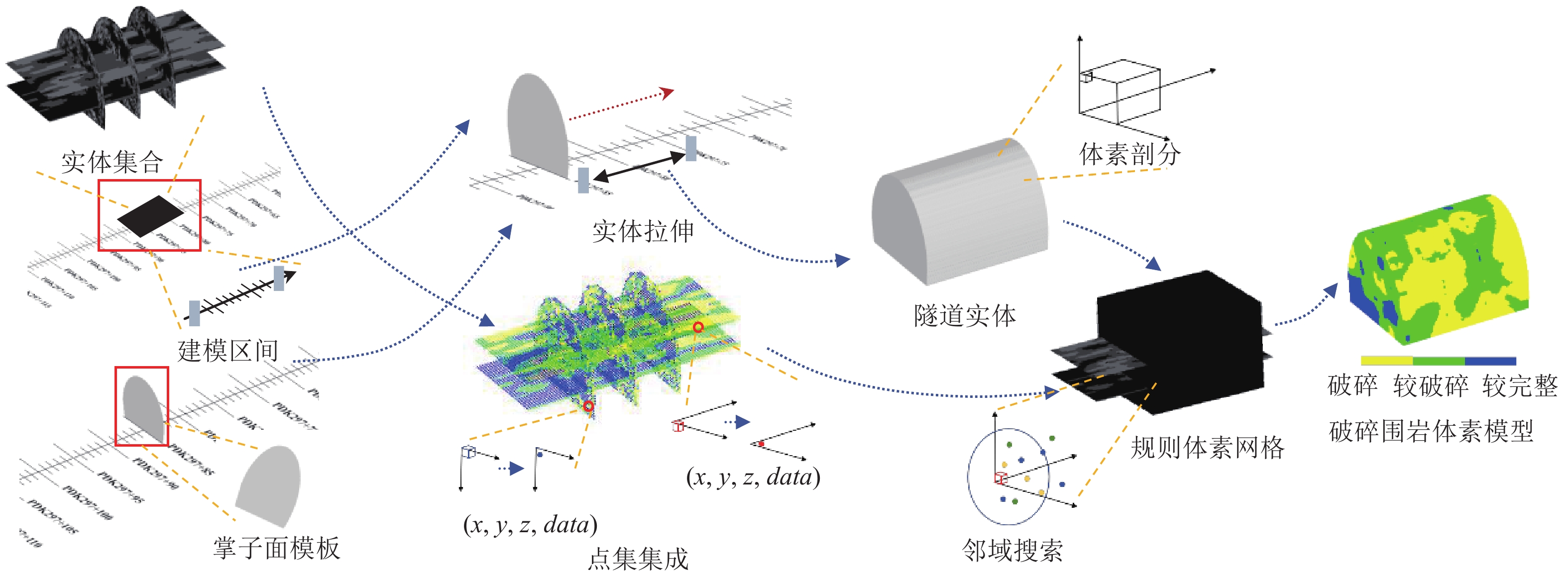
图 4 隧道围岩体素插值建模流程图
Figure 4. Flowchart of voxel interpolation modeling for surrounding rock in tunnels
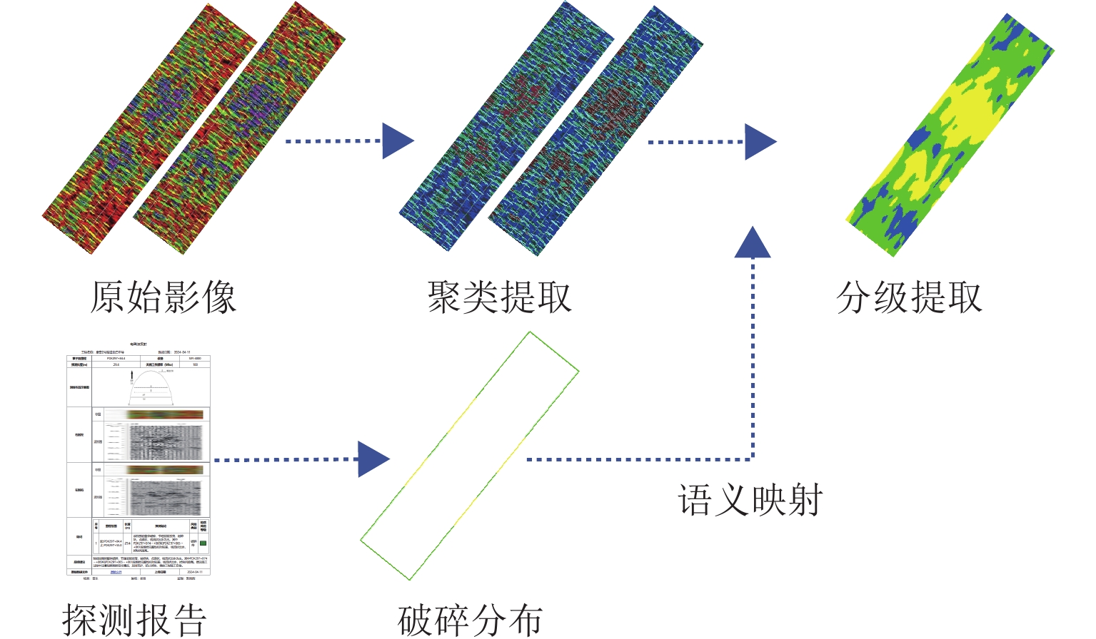
图 6 地质雷达图像破碎分级提取结果
Figure 6. Fracture classification extraction results from ground-penetrating radar images
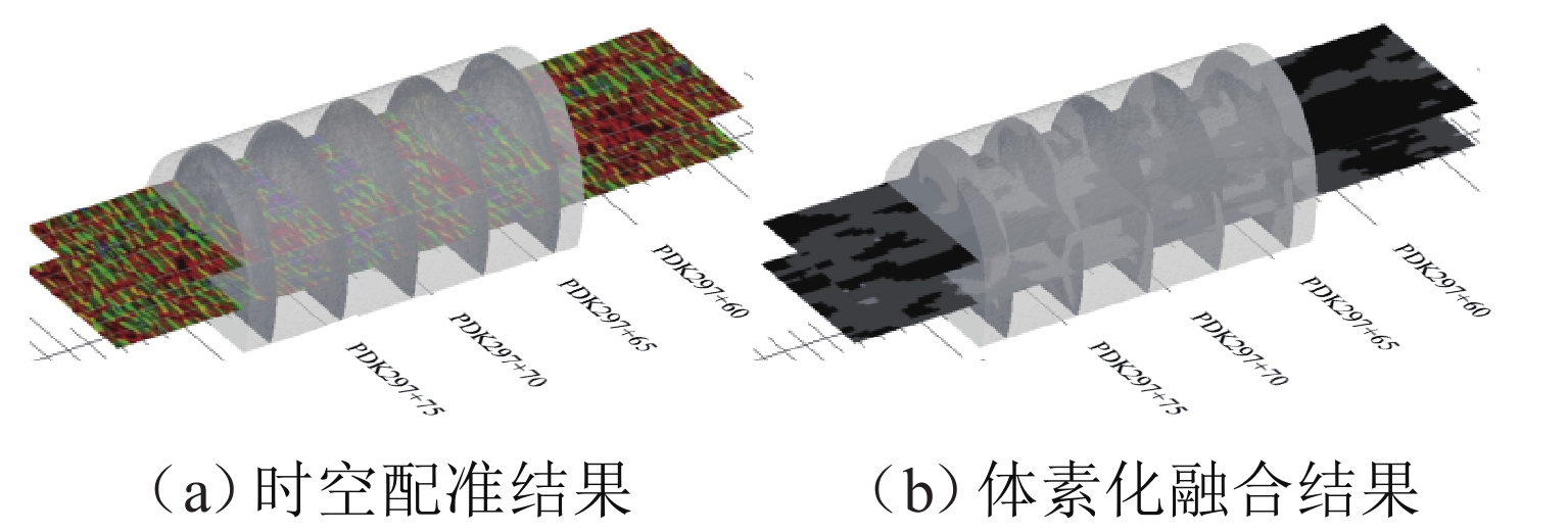
图 7 破碎围岩特征时空配准与体素化融合结果
Figure 7. Spatiotemporal registration and voxelization fusion results of fractured surrounding rock features
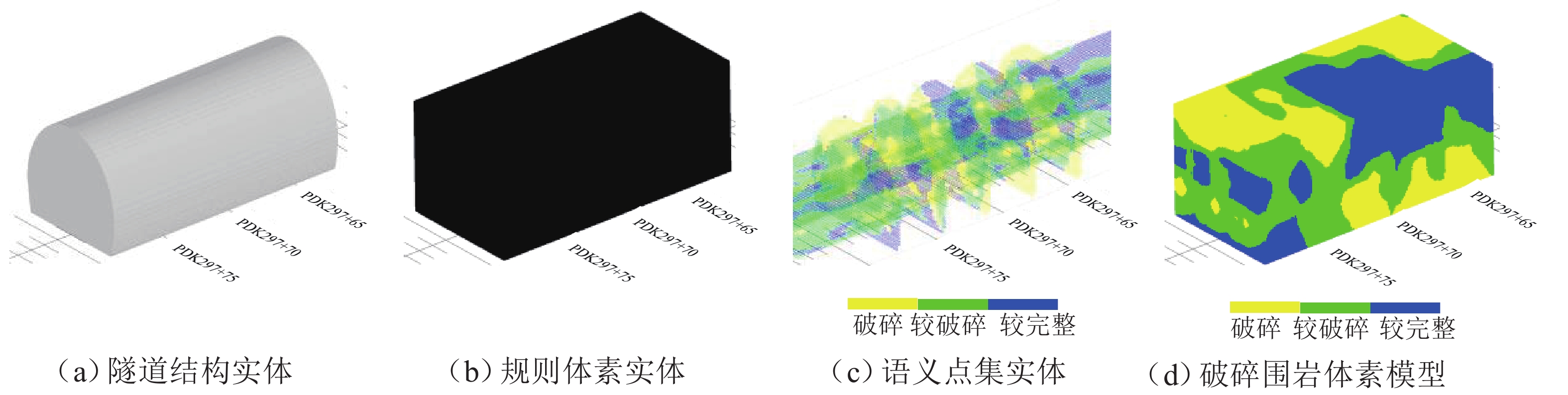
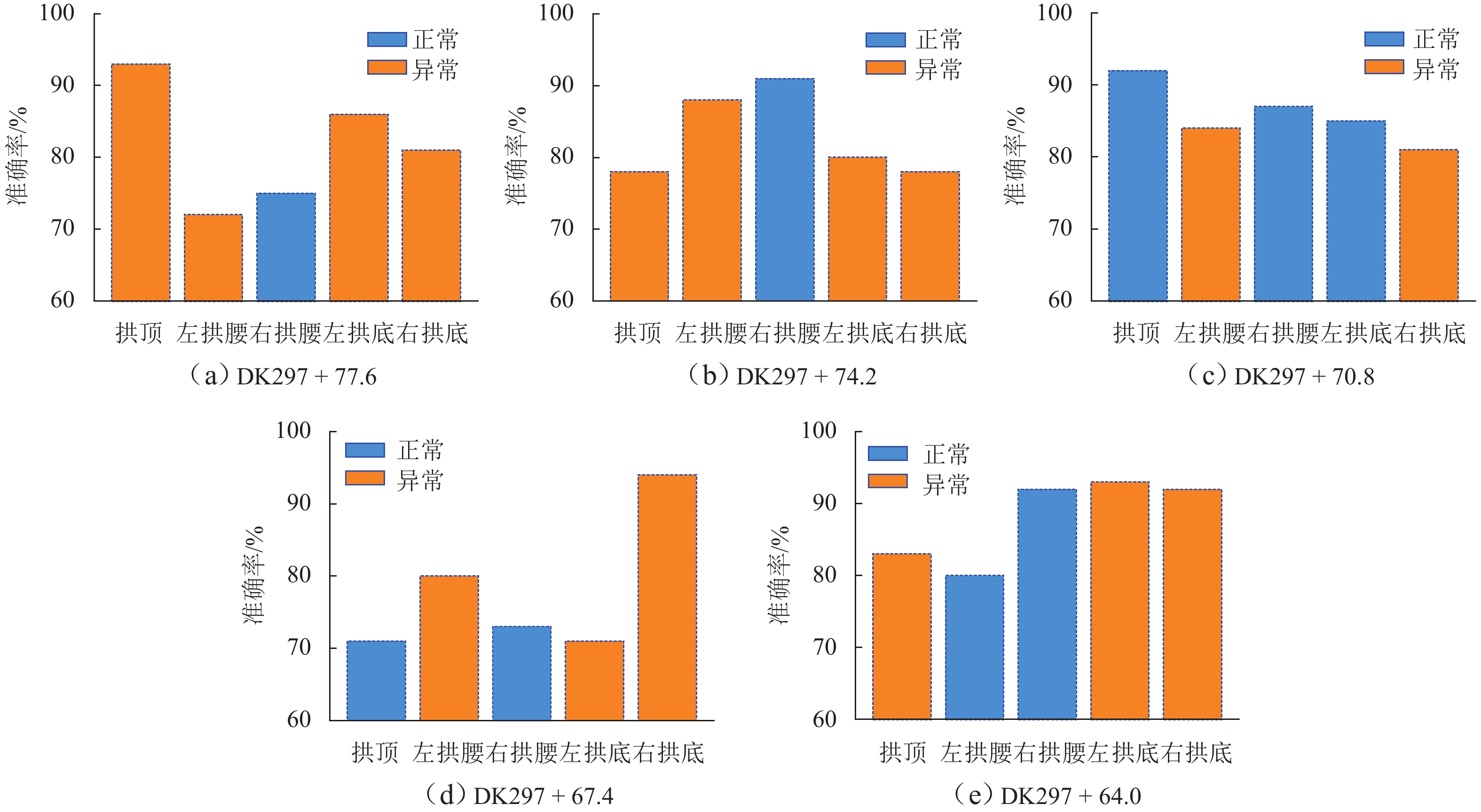
图 8 破碎围岩体素插值建模实验结果
Figure 8. Experimental results of voxel interpolation modeling for fractured surrounding rock
-
[1] 李术才, 刘斌, 孙怀凤, 等. 隧道施工超前地质预报研究现状及发展趋势[J]. 岩石力学与工程学报, 2014, 33(6): 1090-1113. doi: 10.13722/j.cnki.jrme.2014.06.003Li Shucai, Liu Bin, Sun Huaifeng, et al. State of art and trends of advanced geological prediction in tunnel construction[J]. Chinese Journal of Rock Mechanics and Engineering, 2014, 33(6): 1090-1113. doi: 10.13722/j.cnki.jrme.2014.06.003 [2] 朱庆, 张利国, 丁雨淋, 等. 从实景三维建模到数字孪生建模[J]. 测绘学报, 2022, 51(6): 1040-1049.Zhu Qing, Zhang Liguo, Ding Yulin, et al. From real 3D modeling to digital twin modeling[J]. Acta Geodaetica et Cartographica Sinica, 2022, 51(6): 1040-1049. [3] 彭建兵, 崔鹏, 庄建琦. 川藏铁路对工程地质提出的挑战[J]. 岩石力学与工程学报, 2020, 39(12): 2377-2389.Peng Jianbing, Cui Peng, Zhuang Jianqi. Challenges to engineering geology of Sichuan: Tibet railway[J]. Chinese Journal of Rock Mechanics and Engineering, 2020, 39(12): 2377-2389. [4] 田四明, 王伟, 唐国荣, 等. 川藏铁路隧道工程重大不良地质应对方案探讨[J]. 隧道建设(中英文), 2021, 41(5): 697-712.Tian Siming, Wang Wei, Tang Guorong, et al. Study on countermeasures for major unfavorable geological issues of tunnels on Sichuan-Tibet railway[J]. Tunnel Construction, 2021, 41(5): 697-712. [5] 薛翊国, 孔凡猛, 杨为民, 等. 川藏铁路沿线主要不良地质条件与工程地质问题[J]. 岩石力学与工程学报, 2020, 39(3): 445-468.Xue Yiguo, Kong Fanmeng, Yang Weimin, et al. Main unfavorable geological conditions and engineering geological problems along Sichuan—Tibet railway[J]. Chinese Journal of Rock Mechanics and Engineering, 2020, 39(3): 445-468. [6] Li S C, Liu B, Xu X J, et al. An overview of ahead geological prospecting in tunneling[J]. Tunnelling and Underground Space Technology, 2017, 63: 69-94. doi: 10.1016/j.tust.2016.12.011 [7] 朱庆, 郑威鹏, 吴浩宇, 等. 基于模糊贝叶斯网络的隧道围岩富水破碎风险分析方法[J]. 西南交通大学学报, 2025, 60(5): 1071-1079.Zhu Qing, Zheng Weipeng, Wu Haoyu, et al. Analysis method for water-rich and fractured risks in tunnel surrounding rock based on fuzzy Bayesian network[J]. Journal of Southwest Jiaotong University, 2025, 60(5): 1071-1079. [8] 高树全, 蒋良文, 牟元存, 等. 西南复杂艰险山区铁路隧道超前地质预报技术[J]. 现代隧道技术, 2024, 61(2): 52-59.Gao Shuquan, Jiang Liangwen, Mou Yuancun, et al. Advanced geological forecasting techniques for railway tunnels in the complex and treacherous mountainous areas of southwest China[J]. Modern Tunnelling Technology, 2024, 61(2): 52-59. [9] Chen J Y, Zhang D M, Huang H W, et al. Image-based segmentation and quantification of weak interlayers in rock tunnel face via deep learning[J]. Automation in Construction, 2020, 120: 103371. doi: 10.1016/j.autcon.2020.103371 [10] 冷彪, 张毅, 杨辉, 等. 隧道掌子面岩体裂隙快速识别方法[J]. 西南交通大学学报, 2021, 56(2): 246-252, 322.Leng Biao, Zhang Yi, Yang Hui, et al. Rapid recognition of rock mass fractures in tunnel faces[J]. Journal of Southwest Jiaotong University, 2021, 56(2): 246-252,322. [11] 陈培帅, 袁青, 张子平, 等. 基于卷积神经网络的隧道富水破碎带地质超前预报图像解译方法[J]. 应用基础与工程科学学报, 2022, 30(1): 196-207. doi: 10.16058/j.issn.1005-0930.2022.01.016Chen Peishuai, Yuan Qing, Zhang Ziping, et al. Image interpretation method for geological advance prediction in water-rich fracture zone of tunnel based on convolutional neural network[J]. Journal of Basic Science and Engineering, 2022, 30(1): 196-207. doi: 10.16058/j.issn.1005-0930.2022.01.016 [12] 温世儒, 杨晓华, 郭元术. 基于频谱能量分析的地质雷达探测图像判读[J]. 工程科学与技术, 2020, 52(6): 120-130. doi: 10.15961/j.jsuese.202000221Wen Shiru, Yang Xiaohua, Guo Yuanshu. Interpretation based on frequency spectrum energy analysis of ground penetrating radar detection image[J]. Advanced Engineering Sciences, 2020, 52(6): 120-130. doi: 10.15961/j.jsuese.202000221 [13] Yang B R, Ding Y L, Zhu Q, et al. Implicit modelling and dynamic update of tunnel unfavourable geology based on multi-source data fusion using support vector machine[J]. Georisk: Assessment and Management of Risk for Engineered Systems and Geohazards, 2024, 18(1): 257-274. doi: 10.1080/17499518.2023.2239778 [14] Luo T, Zhu S, Yikeremu Y, et al. Ground penetrating radar applied to subsurface culverts[J]. Geo-spatial Information Science, 2024, 27(6): 2092-2108. doi: 10.1080/10095020.2023.2238758 [15] Lalagüe A, Lebens M A, Hoff I, et al. Detection of rockfall on a tunnel concrete lining with ground-penetrating radar (GPR)[J]. Rock Mechanics and Rock Engineering, 2016, 49(7): 2811-2823. doi: 10.1007/s00603-016-0943-y [16] Cardarelli E, Marrone C, Orlando L. Evaluation of tunnel stability using integrated geophysical methods[J]. Journal of Applied Geophysics, 2003, 52(2/3): 93-102. doi: 10.1016/s0926-9851(02)00242-2 [17] Xie E, Wang W H, Yu Z D, et al. SegFormer: Simple and efficient design for semantic segmentation with transformers[J]. Advances in Neural Information Processing Systems, 2021, 34: 12077-12090. [18] Li M L, Rui J, Yang S K, et al. Method of building detection in optical remote sensing images based on SegFormer[J]. Sensors, 2023, 23(3): 1258. doi: 10.3390/s23031258 [19] Bai H T, Wang P H, Zhang R F, et al. SegFormer: a topic segmentation model with controllable range of attention[J]. Proceedings of the AAAI Conference on Artificial Intelligence, 2023, 37(11): 12545-12552. doi: 10.1609/aaai.v37i11.26477 [20] Lin X F, Cheng Y W, Chen G, et al. Semantic segmentation of China’s coastal wetlands based on sentinel-2 and segformer[J]. Remote Sensing, 2023, 15(15): 3714. doi: 10.3390/rs15153714 [21] Steinley D. K-means clustering: a half-century synthesis[J]. British Journal of Mathematical and Statistical Psychology, 2006, 59(1): 1-34. doi: 10.1348/000711005X48266 [22] Ahmed M, Seraj R, Islam S M S. The k-means algorithm: a comprehensive survey and performance evaluation[J]. Electronics, 2020, 9(8): 1295. doi: 10.3390/electronics9081295 [23] Museth K, Lait J, Johanson J, et al. OpenVDB: an open-source data structure and toolkit for high-resolution volumes[C]//ACM SIGGRAPH 2013 Courses. Anaheim California. ACM, 2013: 1-1. [24] Museth K. VDB: High-resolution sparse volumes with dynamic topology[J]. ACM Transactions on Graphics, 2013, 32(3): 1-22. [25] Wu H Y, Zhu Q, Guo Y X, et al. Multi-level voxel representations for digital twin models of tunnel geological environment[J]. International Journal of Applied Earth Observation and Geoinformation, 2022, 112: 102887. doi: 10.1016/j.jag.2022.102887 [26] Liu H, Chen S Z, Hou M Q, et al. Improved inverse distance weighting method application considering spatial autocorrelation in 3D geological modeling[J]. Earth Science Informatics, 2020, 13(3): 619-632. doi: 10.1007/s12145-019-00436-6 [27] Liu Z, Zhang Z L, Zhou C Y, et al. An adaptive inverse-distance weighting interpolation method considering spatial differentiation in 3D geological modeling[J]. Geosciences, 2021, 11(2): 51. doi: 10.3390/geosciences11020051 [28] 云安萍, 鞠正山, 胡克林, 等. 基于距离反比法的土壤盐分三维空间插值研究[J]. 农业机械学报, 2015, 46(12): 148-156, 172.Yun Anping, Ju Zhengshan, Hu Kelin, et al. Three-dimensional spatial interpolation of soil salinity based on inverse distance weighting method[J]. Transactions of the Chinese Society for Agricultural Machinery, 2015, 46(12): 148-156,172. -

 下载:
下载:

 点击查看大图
计量
- 文章访问数: 8
- HTML全文浏览量: 5
- PDF下载量: 0
- 被引次数: 0