Lightweight Web Visualization of Massive Road Traffic Data
-
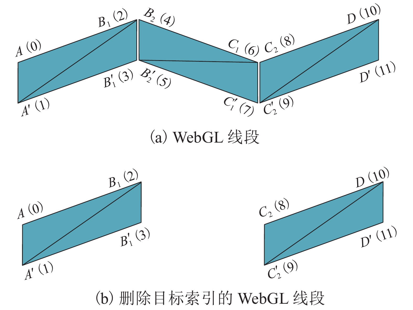
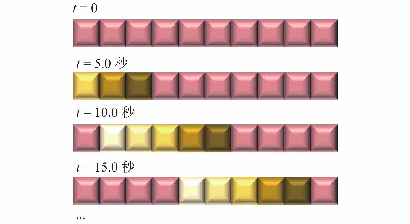
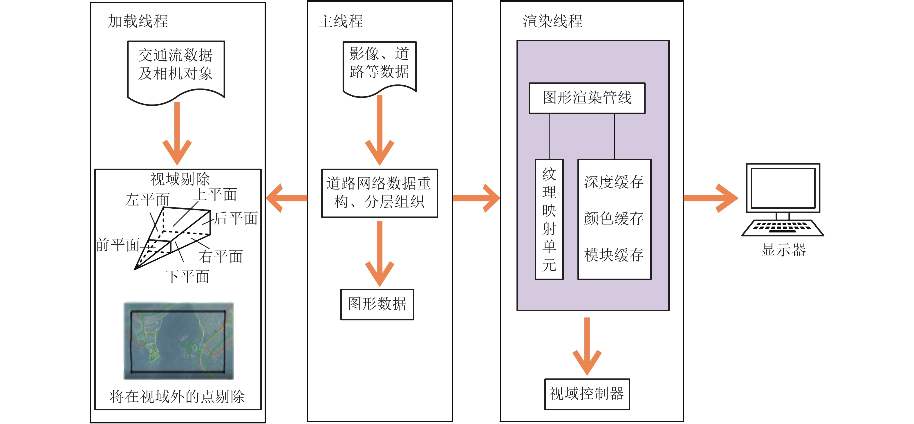
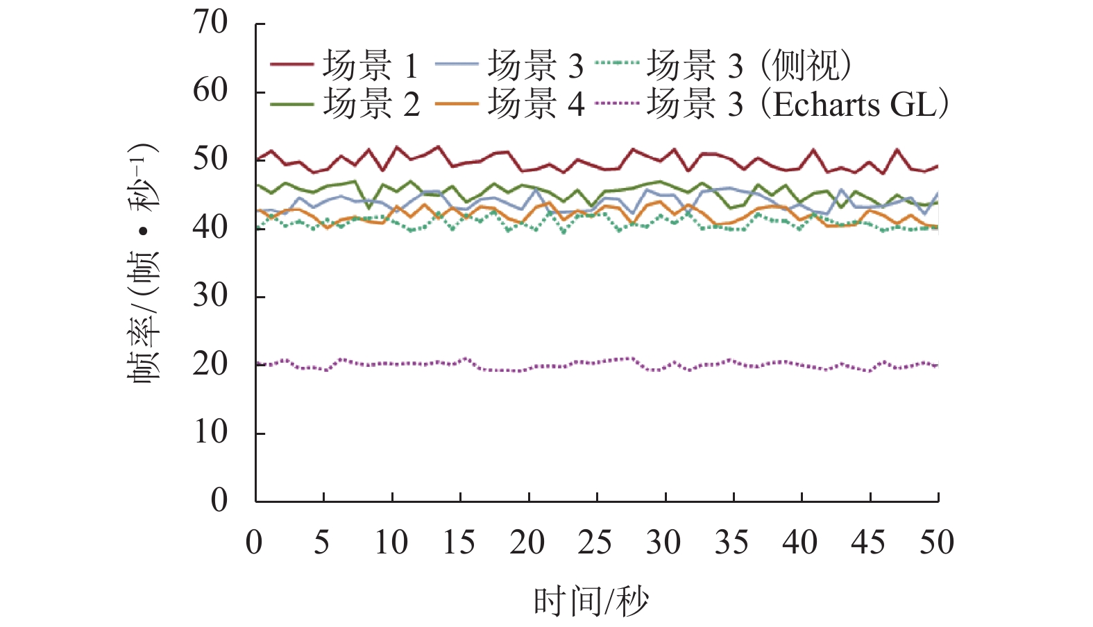
摘要: 为提高网络环境下大规模道路交通数据动态可视化效率,提出一种在网络环境下使用流光线表达交通态势的轻量化可视化方法. 首先,提出顾及道路属性的路网分层组织方法,并绘制在不同视角高度下的道路;然后,提出基于WebGL (Web graghics library)技术线段索引特点的多道路合并方法,并结合视域剔除以及多线程技术对场景进行优化,设计实现了支持道路拥堵状态实时变换的渐变、动态流光线等动画效果;最后,研发了原型系统,并以全国道路网数据为例进行案例实验与分析. 实验结果表明:在网络环境下进行大规模道路交通数据动态可视化,本文方法可视化帧率稳定在40帧/秒以上,相较于百度ECharts GL可视化方法提高了20~30帧/秒.Abstract: In order to further improve the dynamic visualization efficiency of large-scale road traffic data under the network environment, a lightweight visualization method using streaminglight is proposed to express traffic situation under the network environment. The hierarchical organization method of road network that allows road attributes is proposed, and the roads are drawnunder different view heights. The multi-road merging method based on the characteristics of line segment index in WebGL (Web graghics library) technology is presented, and the scene is optimized by combining the visual field elimination and multithreading technology. The animation effects such as gradual change and dynamic streaming light that support the real-time transformation of road congestion state are designed and realized. Finally, the prototype system is developed, and the case experiment and analysis are carried out with the national road network data. Experimental results show that this method can dynamically visualize large-scale road traffic data under the network environment, and its visualization frame rate is stable above 40 frames/s, which is 20−30 frames/s higher than that of the Baidu ECharts GL visualization method.
-
Key words:
- road traffic data /
- large-scale scene /
- streaming light /
- scene optimization /
- visualization
-
表 1 不同颜色的流光线
Table 1. Different colors of streaming light
车道颜色 流光线头部颜色 流光线尾部颜色 交通态势 (0,175,0) (154,255,154) (124,205,124) 不拥堵 (218,218,0) (255,255,180) (205,233,90) 比较拥堵 (238,64,0) (255,114,86) (205,91,69) 拥堵 表 2 不同场景下参数记录
Table 2. Parameter records in different scenarios
场景 视角高/km 道路数/条 分段后道路点数/个 道路点索引数/个 一级 二级 三级 四级 Ⅰ层 Ⅱ层 Ⅲ层 Ⅳ层 Ⅰ层 Ⅱ层 Ⅲ层 Ⅳ层 1 7000.0 205 0 0 0 43125 0 0 0 257520 0 0 0 2 40.0 6 60 0 0 4913 14739 0 0 29442 88074 0 0 3 5.0 1 16 59 0 846 7526 16282 0 5070 45060 97338 0 4 0.5 0 0 0 2 0 0 0 437 0 0 0 2610 -
姜晓睿,田亚,蒋莉,等. 城市道路交通数据可视分析综述[J]. 中国图象图形学报,2015,20(4): 454-467. doi: 10.11834/jig.20150401JIANG Xiaorui, TIAN Ya, JIANG Li, et al. Visual analytics of urban road transportation data:a survey[J]. Journal of Image and Graphics, 2015, 20(4): 454-467. doi: 10.11834/jig.20150401 胡启洲,孙煦. 基于多维联系数的城市路网交通拥堵态势监控模型[J]. 中国公路学报,2013,26(6): 143-149. doi: 10.3969/j.issn.1001-7372.2013.06.020HU Qizhou, SUN Xu. Model for traffic congestion state monitor in urban road network based on multi-dimension connection number[J]. China Journal of Highway and Transport, 2013, 26(6): 143-149. doi: 10.3969/j.issn.1001-7372.2013.06.020 张昀昊,朱军,李维炼,等. 面向多样化终端的自适应网络三维可视化方法[J]. 西南交通大学学报,2019,54(5): 989-996. doi: 10.3969/j.issn.0258-2724.20180399ZHANG Yunhao, ZHU Jun, LI Weilian, et al. Adaptive Web 3D visualization method for diverse terminals[J]. Journal of Southwest Jiaotong University, 2019, 54(5): 989-996. doi: 10.3969/j.issn.0258-2724.20180399 ZHANG Yunhao, ZHU Jun, LI Weilian, et al. Adaptive construction of the virtual debris flow disaster environments driven by multilevel visualization task[J]. ISPRS International Journal of Geo-Information, 2019, 8(5): 209-224. doi: 10.3390/ijgi8050209 朱庆,陈兴旺,丁雨淋,等. 视觉感知驱动的三维城市场景数据组织与调度方法[J]. 西南交通大学学报,2017,52(5): 869-876. doi: 10.3969/j.issn.0258-2724.2017.05.005ZHU Qing, CHEN Xingwang, DING Yulin, et al. Organization and scheduling method of 3D urban scene data driven by visual perception[J]. Journal of Southwest Jiaotong University, 2017, 52(5): 869-876. doi: 10.3969/j.issn.0258-2724.2017.05.005 HU Ya, ZHU Jun, LI Weilian, et al. Construction and optimization of three-dimensional disaster scenes within mobile virtual reality[J]. ISPRS International Journal of Geo-Information, 2018, 7(6): 215-230. doi: 10.3390/ijgi7060215 LI Weilian, ZHU Jun, ZHANG Yunhao, et al. A fusion visualization method for disaster information based on self-explanatory symbols and photorealistic scene cooperation[J]. ISPRS International Journal of Geo-Information, 2019, 8(3): 104-119. doi: 10.3390/ijgi8030104 张昀昊,朱庆,朱军,等. 海量DSM数据的网络轻量化可视化方法[J]. 测绘科学技术学报,2017,34(6): 649-653.ZHANG Yunhao, ZHU Qing, ZHU Jun, et al. Lightweight web visualization of massive DSM data[J]. Journal of Geomatics Science and Technology, 2017, 34(6): 649-653. 欧阳峰,龚桂荣,何列松. 面向WebGL的矢量数据三维绘制技术[J]. 测绘科学技术学报,2016,33(6): 635-638,643.OUYANG Feng, GONG Guirong, HE Liesong. Vector 3D rendering techniques based on WebGL[J]. Journal of Geomatics Science and Technology, 2016, 33(6): 635-638,643. 黄丽平. 基于轨迹数据的城市交通网络监控方法研究[D]. 长春: 吉林大学, 2018. 李清泉,黄练,谭文霞. 基于道路特征的海量GPS监控数据压缩方法[J]. 武汉大学学报(信息科学版),2008,33(4): 337-340,352.LI Qingquan, HUANG Lian, TAN Wenxia. Mass GPS tracking data compression method based on road features[J]. Geomatics and Information Science of Wuhan University, 2008, 33(4): 337-340,352. 杨洪泉. 大众电子地图的应用现状及发展趋势[J]. 测绘通报,2014(11): 37-41.YANG Hongquan. Application status and development trend of the electronic public map[J]. Bulletin of Surveying and Mapping, 2014(11): 37-41. 邓晨晨. 城市居民公交出行数据分析研究及可视化[D]. 重庆: 重庆大学, 2016. TOMINSKI C, SCHUMANN H, ANDRIENKO G, et al. Stacking-based visualization of trajectory attribute data[J]. IEEE Transactions on Visualization and Computer Graphics, 2012, 18(12): 2565-2574. doi: 10.1109/TVCG.2012.265 任磊,杜一,马帅,等. 大数据可视分析综述[J]. 软件学报,2014,25(9): 1909-1936.REN Lei, DUYi, ZHANG Xiaolong, et al. Visual analytics towards big data[J]. Journal of Software, 2014, 25(9): 1909-1936. 嵇晓峰,张丰,王中一,等. 基于着色模型实时构造的海洋流场动态流线可视化方法研究[J]. 浙江大学学报(理学版),2020,47(1): 45-51. doi: 10.3785/j.issn.1008-9497.2020.01.006JI Xiaofeng, ZHANG Feng, WANG Zhongyi, et al. Research on dynamic streamline visualization of ocean flow field with real-time construction of coloring model[J]. Journal of Zhejiang University (Science Edition), 2020, 47(1): 45-51. doi: 10.3785/j.issn.1008-9497.2020.01.006 谢雪景,欧国健,周艺. 基于自发地理信息的人行道路信息提取[J]. 地理信息世界,2019,26(1): 92-98. doi: 10.3969/j.issn.1672-1586.2019.01.017XIE Xuejing, OU Guojian, ZHOU Yi. Pedestrian road information extraction based on volunteered geographic information[J]. Geomatics World, 2019, 26(1): 92-98. doi: 10.3969/j.issn.1672-1586.2019.01.017 中华人民共和国住房和城乡建设部. 城市道路工程设计规范: CJJ 37—2012[S]. 北京: 中国建筑工业出版社, 2016. 朱庆,翁其强,胡翰,等. 网络环境下全景图和点云数据快速融合可视化方法[J]. 西南交通大学学报,2019,54(2): 269-277. doi: 10.3969/j.issn.0258-2724.20200360ZHU Qing, WENG Qiqiang, HU Han, et al. Multi-view image precise texture mapping method based on frame buffer[J]. Journal of Southwest Jiaotong University, 2019, 54(2): 269-277. doi: 10.3969/j.issn.0258-2724.20200360 聂良涛,易思蓉,李阳. 基于网络地理信息服务的选线数字地形获取方法[J]. 西南交通大学学报,2015,50(5): 803-810. doi: 10.3969/j.issn.0258-2724.2015.05.006NIE Liangtao, YI Sirong, LI Yang. Web geographic information services-based acquisition method of digital terrain data for highway location[J]. Journal of Southwest Jiaotong University, 2015, 50(5): 803-810. doi: 10.3969/j.issn.0258-2724.2015.05.006 -


 下载:
下载:


