Spatial Development Characteristics of Post-Fire Debris Flow in Bajiaolou Town
-
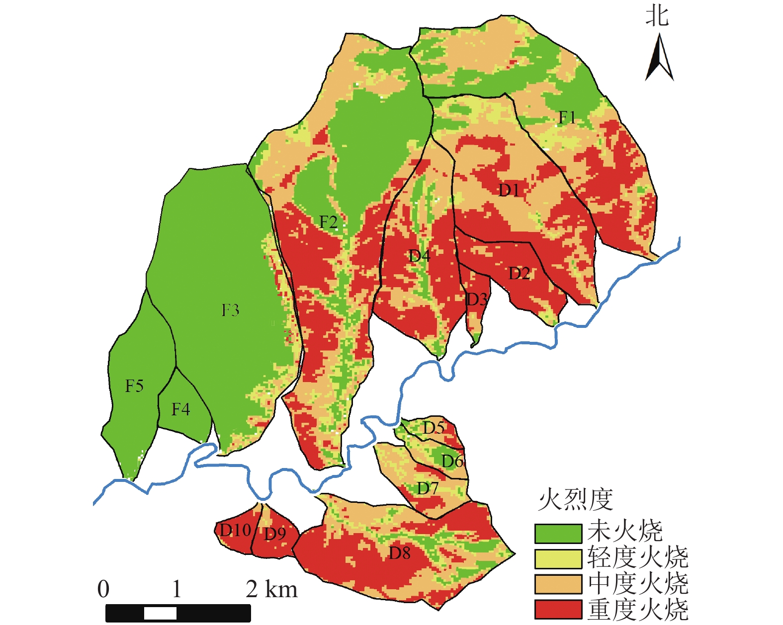
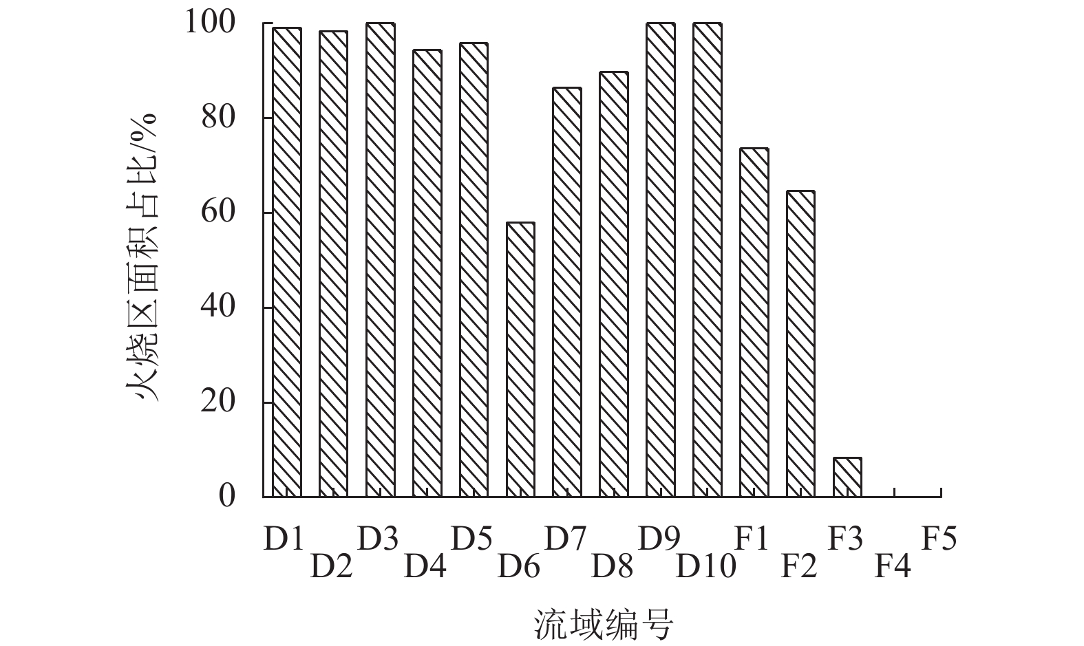
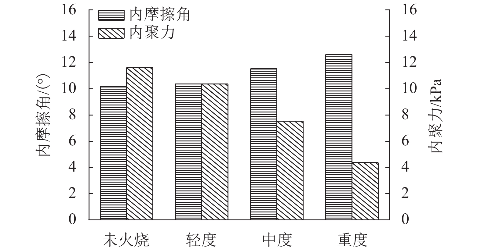
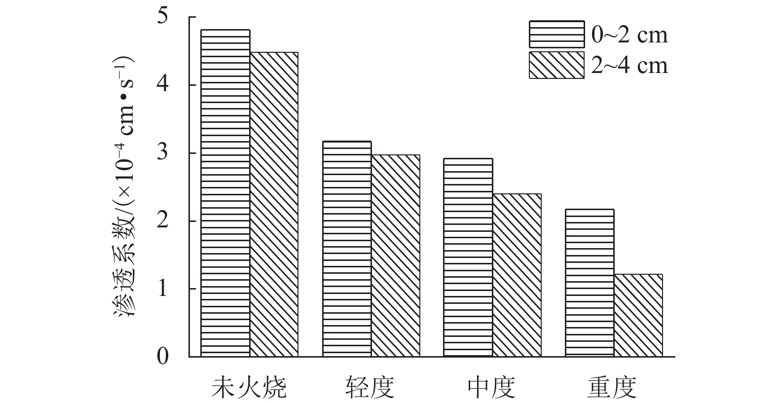
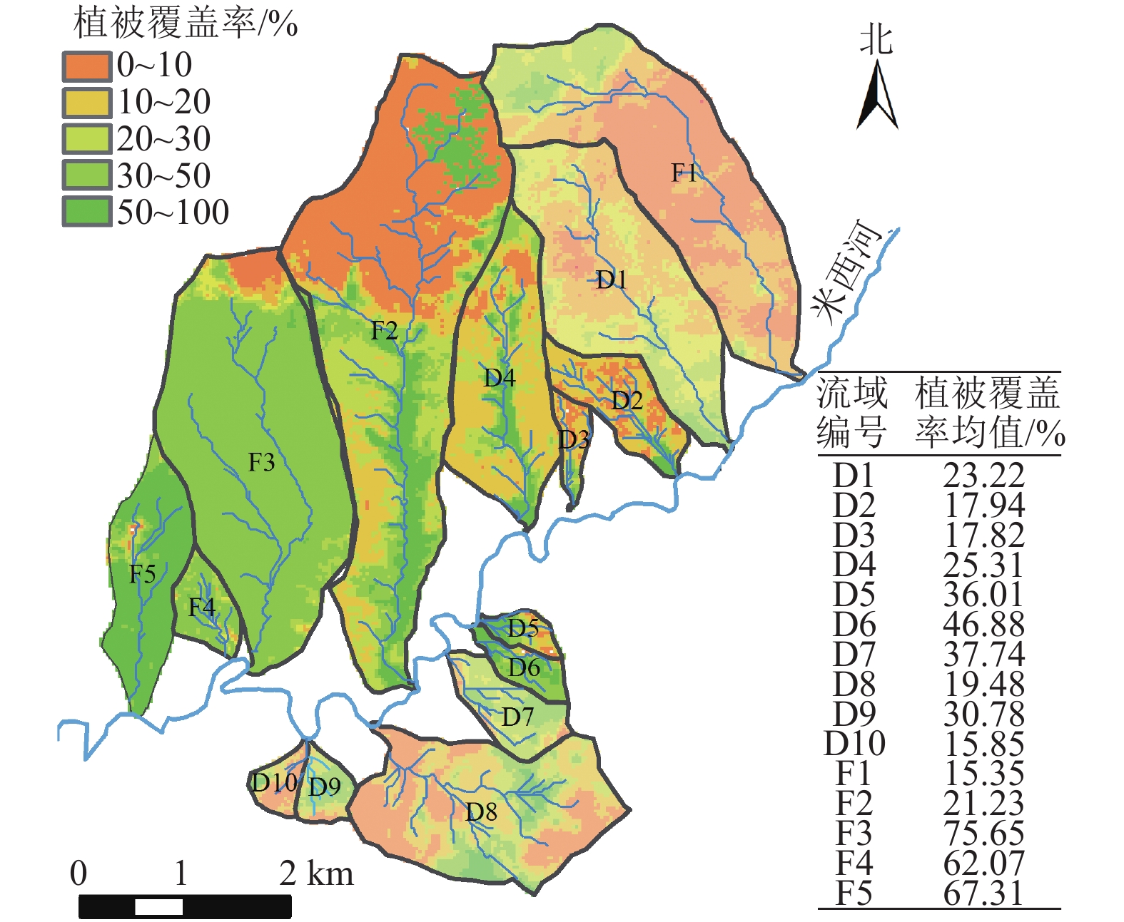
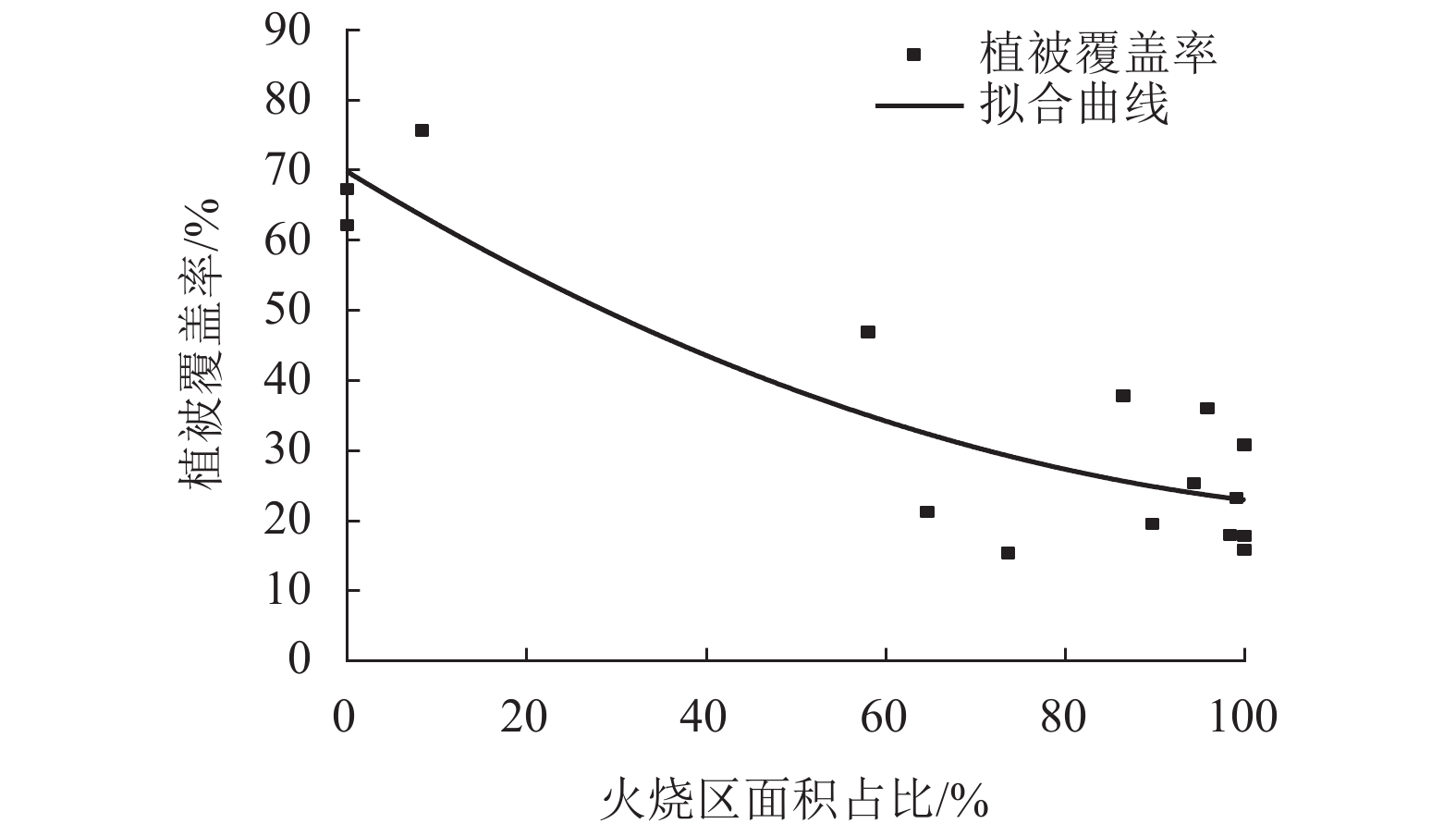
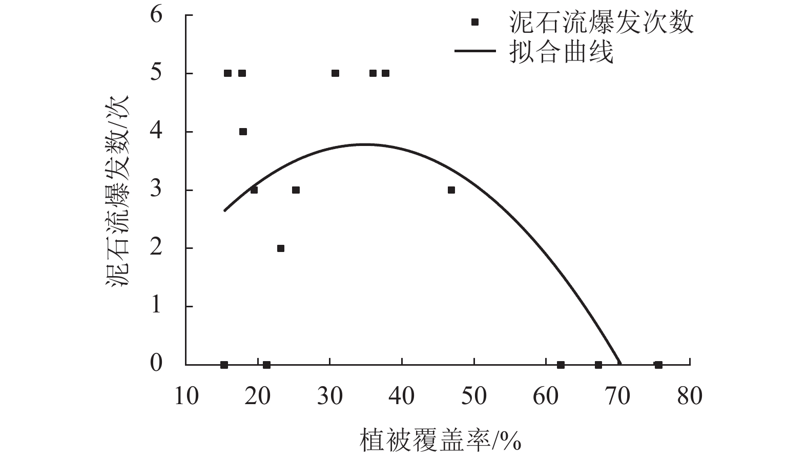
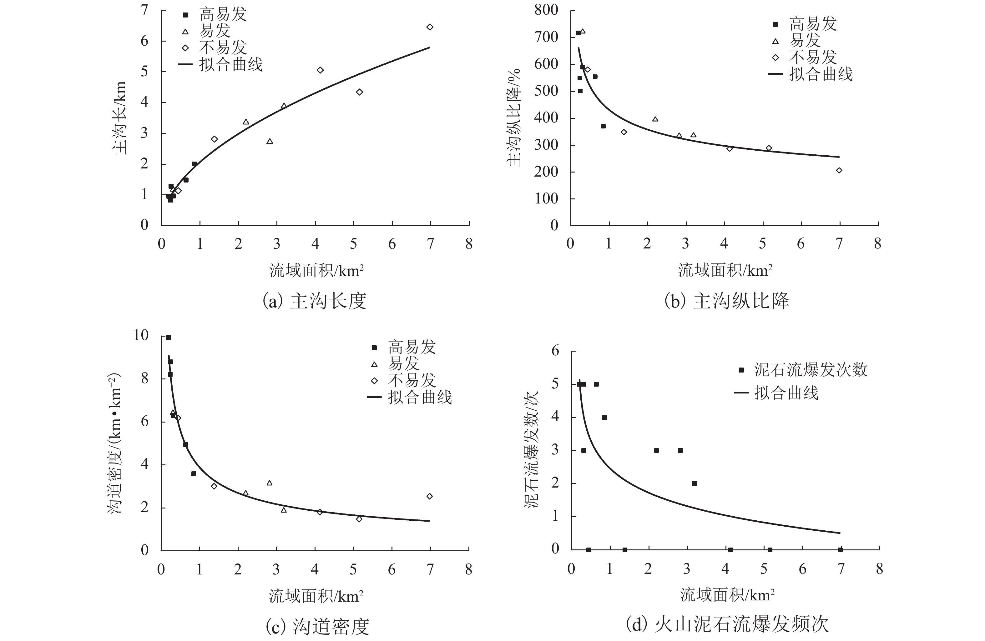
摘要: 作为一种与林火密切相关的特殊泥石流,火后泥石流的形成具有明显的空间差异性,对其空间发育特征及影响因素的分析有利于此类泥石流的防灾减灾. 运用现场调查、室内外试验和遥感解译等手段,对雅江县八角楼乡火烧迹地15条沟道的火后泥石流发育特征及地形、林火、植被特征、降雨条件进行了多元分析. 结果表明:火烈度越强,土壤的物理力学性质劣化越严重,斥水性越强,渗透性越低,泥石流越易形成;流域过火面积越大,植被覆盖率越低,泥石流暴发频率越高;相对于大流域,小而陡的流域反而更易暴发火后泥石流. 此外,研究区内暴发的5次火后泥石流中有4次泥石流其激发雨强重复周期均小于5 a,且随着时间的增长激发雨强也逐渐升高.Abstract: As a special type of debris flows closely relevant to forest fire, the generation of post-fire debris flow often shows a spatial variation. It is of great significance to analyze the spatial development characteristics and its influencing factors for hazard mitigation and reduction. By means of field investigation, in-situ and laboratory tests, and remote sensing interpretation, multi-factor analysis was conducted on the 15 channels in the burned area in Bajiaolou town of Yajiang county in terms of their spatial development characteristics, topography, forest fire, vegetation and rainfall conditions. The results show that the higher the fire intensity, the stronger the soil water repellency and the lower the permeability; moreover, the physical and mechanical properties of soil deteriorate more seriously, which contribute to the generation of post-fire debris flow. The occurrence frequency of post-fire debris flow rises when the burned area become larger and the vegetation cover coefficient lower. In contrast to the large basins, the smaller basins show more vulnerability to post-fire debris flow for their short channel lengths and high longitudinal slopes. Besides, the recurrence time of the triggering rainfall intensity that corresponds to four of five debris-flow events in the study areas is less than 5 years, and the triggering rainfall intensity also increases with time.
-
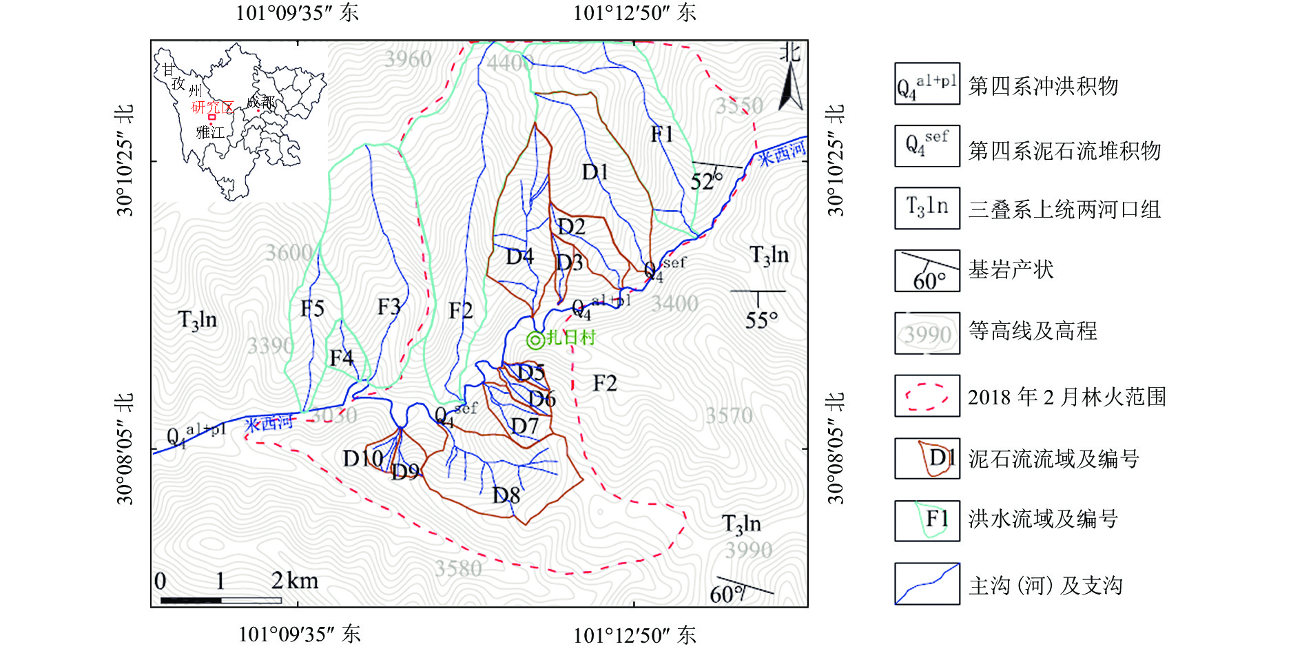
表 1 2018年火烧迹地泥石流暴发情况统计
Table 1. Statistics of post-fire debris flow occurred in burnt area in 2018
流域 是否发生泥石流和洪水 是否过火 暴发频次/次 易发性 6月13日 6月24日 6月30日 7月5日 7月12日 D1 × × × √ √ 是 2 L D2 √ × √ √ √ 是 4 H D3 √ √ √ √ √ 是 5 H D4 × × √ √ √ 是 3 L D5 √ √ √ √ √ 是 5 H D6 × × √ √ √ 是 3 L D7 √ √ √ √ √ 是 5 H D8 × × √ √ √ 是 3 L D9 √ √ √ √ √ 是 5 H D10 √ √ √ √ √ 是 5 H F1 × × × × × 是 0 N F2 × × × × × 是 0 N F3 × × × × × 是 0 N F4 × × × × × 否 0 N F5 × × × × × 否 0 N 注:“√”表示发生了泥石流,“×”表示只发生了洪水;“L”表示易发,“H”表示高易发,“N”表示不易发. 表 2 火烧迹地坡表土壤物理性质试验结果
Table 2. Tested physical properties of soil on slope in study area
火烈度 密度/(g•cm−3) 含水率/% 比重 干密度/(g•cm−3) 孔隙度/% 未火烧(对照组) 1.51 ± 0.08 (a) 4.77 ± 0.30 (a) 2.62 ± 0.01 (a,b) 1.44 ± 0.08 (a) 45.14 ± 3.08 (b) 轻度 1.30 ± 0.03 (a,b) 3.89 ± 0.44 (a,b) 2.62 ± 0.01 (a,b) 1.25 ± 0.03 (a,b) 52.28 ± 1.28 (a,b) 中度 1.20 ± 0.08 (b) 2.69 ± 0.34 (b) 2.63 ± 0.01(a) 1.17 ± 0.08 (b) 55.66 ± 3.17 (a) 重度 1.14 ± 0.04 (b) 1.14 ± 0.26 (c) 2.59 ± 0.01 (b) 1.12 ± 0.04 (b) 56.66 ± 1.40 (a) 注:表中数据为均值 ± 标准误差;a、b、c反映单因素方差分析结果,同列数据不同字母表示均值差异性显著(P值小于0.05). 表 3 各火烈度区坡表不同深度处不同斥水土壤样本含量占比
Table 3. Proportion of hydrophobic soil samples at different depths in areas with different fire intensities
深度/cm 火烈度 样本含量占比/% 斥水性土壤
占比合计/%N L M H 0 W 72.48 23.91 2.45 1.16 27.52 Q 42.22 26.93 7.81 23.04 57.78 Z 29.79 28.61 14.62 26.98 70.21 Y 25.42 28.59 12.05 33.94 74.58 1 W 93.04 4.16 1.53 1.27 6.96 Q 93.53 2.57 0.86 3.04 6.47 Z 51.07 32.01 7.64 9.28 48.93 Y 52.24 33.81 5.97 7.98 47.76 2 W 97.05 1.23 0.44 1.28 2.95 Q 97.12 1.54 0.53 0.81 2.88 Z 88.21 6.53 2.64 2.62 11.79 Y 87.53 7.62 1.56 3.29 12.47 3 W 97.13 0.82 1.21 0.84 2.87 Q 96.43 1.68 0.87 1.02 3.57 Z 96.49 1.07 0.99 1.45 3.51 Y 94.35 1.86 1.98 1.81 5.65 注:“W”为未火烧,“Q”为轻度火烧,“Z”为中度火烧,“Y”为重度火烧;“N”为亲水,“L”为轻度斥水,“M”为中度斥水,“H”为严重斥水. 表 4 各流域基本地形参数
Table 4. Basic topographic parameters of each basin
流域编号 面积/km2 流域高
差/m主沟长/km 主沟纵比降/‰ 沟道密度/
(km•km−2)D1 3.19 1430 3.88 336.04 1.87 D2 0.85 825 2.00 370.61 3.58 D3 0.25 650 1.28 501.70 8.80 D4 2.20 1445 3.35 395.28 2.67 D5 0.20 624 0.95 717.63 9.93 D6 0.31 761 1.17 722.32 6.42 D7 0.64 870 1.48 555.21 4.95 D8 2.82 1077 2.72 335.14 3.13 D9 0.31 592 0.97 590.58 6.29 D10 0.24 492 0.83 549.63 8.21 F1 4.13 1449 5.06 286.82 1.80 F2 6.98 1501 6.45 206.52 2.54 F3 5.15 1443 4.34 289.46 1.48 F4 0.44 697 1.13 581.34 6.18 F5 1.38 1062 2.81 348.70 3.01 -
NYMAN P, SMITH H G, SHERWIN C B, et al. Predicting sediment delivery from debris flows after wildfire[J]. Geomorphology, 2015, 250: 173-186. doi: 10.1016/j.geomorph.2015.08.023 NYMAN P, SHERIDAN G J, SMITH H G, et al. Evidence of debris flow occurrence after wildfire in upland catchments of south-east Australia[J]. Geomorphology, 2011, 125(3): 383-401. doi: 10.1016/j.geomorph.2010.10.016 GARTNER J E, CANNON S H, BIGIO E R, et al. Compilation of data relating to the erosive response of 606 recently-burned basins in the Western U. S.[R]. Washington D. C.: U. S. Geological Survey, 2005. GABET E J, BOOKTER A. A morphometric analysis of gullies scoured by post-fire progressively bulked debris flows in southwest Montana,USA[J]. Geomorphology, 2008, 96(3/4): 298-309. CANNON S H, GARTNER J E, JAKOB M, et al. Wildfire-related debris flow from a hazards perspective[M]. Berlin: Springer, 2005: 363-385. HYDE K D, WILCOX A C, JENCSO K, et al. Effects of vegetation disturbance by fire on channel initiation thresholds[J]. Geomorphology, 2014, 214: 84-96. doi: 10.1016/j.geomorph.2014.03.013 KEAN J W, STALEY D M, CANNON S H. In situ measurements of post-fire debris flows in southern California:comparisons of the timing and magnitude of 24 debris-flow events with rainfall and soil moisture conditions[J]. Journal of Geophysical Research: Earth Surface, 2011, 116(4): F4019.1-F4019.21. 胡卸文,王严,杨瀛. 火后泥石流成灾特点及研究现状[J]. 工程地质学报,2018,26(6): 1562-1573.HU Xiewen, WANG Yan, YANG Ying. Research actuality and evolution mechanism of post-fire debris flow[J]. Journal of Engineering Geology, 2018, 26(6): 1562-1573. 胡卸文,韩玫,梁敬轩,等. 汶川地震灾区泥石流若干关键问题[J]. 西南交通大学学报,2016,51(2): 331-340. doi: 10.3969/j.issn.0258-2724.2016.02.012HU Xiewen, HAN Mei, LIANG Jingxuan, et al. Some key problems on debris flow in Wenchuan earthquake area[J]. Journal of Southwest Jiaotong University, 2016, 51(2): 331-340. doi: 10.3969/j.issn.0258-2724.2016.02.012 邸雪颖,陶玉柱. 火后泥石流研究进展[J]. 应用生态学报,2013,24(8): 2383-2392.DI Xueying, TAO Yuzhu. Research progress in post-fire debris flow[J]. Chinese Journal of Applied Ecology, 2013, 24(8): 2383-2392. 陈子龙. 仁额拥沟火后泥石流发育特征及成因机制研究[D]. 成都: 成都理工大学, 2016. 任云,胡卸文,王严,等. 四川省九龙县色脚沟火后泥石流成灾机理[J]. 水文地质工程地质,2018,45(6): 150-156.REN Yun, HU Xiewen, WANG Yan, et al. Disaster mechanism of the Sejiao post-fire debris flow in Jiulong county of Sichuan[J]. Hydrogeology and Engineering Geology, 2018, 45(6): 150-156. KEY C H, BENSON N C. Landscape assessment (LA) sampling and analysis methods[M]. Washington D. C.: USDA Forest Service, 2006: 25-26. 王晓莉,王文娟,常禹,等. 基于NBR指数分析大兴安岭呼中森林过火区的林火烈度[J]. 应用生态学报,2013,24(4): 967-974.WANG Xiaoli, WANG Wenjuan, CHANG Yu, et al. Fire severity of burnt area in Huzhong forest region of Great Xing’an Mountains,Northeast China based on normalized burn ration analysis[J]. Journal of Applied Ecology, 2013, 24(4): 967-974. 中华人民共和国水利部. 土工试验方法标准: GB/T 50123—1999[S]. 北京: 中国计划出版社, 1999. BADÍA-VILLAS D, GONZÁLEZ-PÉREZ J A, AZNAR J M, et al. Changes in water repellency,aggregation and organic matter of a mollic horizon burned in laboratory:Soil depth affected by fire[J]. Geoderma, 2014, 213: 400-407. doi: 10.1016/j.geoderma.2013.08.038 ROBICHAUD P R, WAGENBRENNER J W, PIERSON F B, et al. Infiltration and interrill erosion rates after a wildfire in western Montana,USA[J]. Catena, 2016, 142: 77-88. doi: 10.1016/j.catena.2016.01.027 张颖,牛健植,谢宝元,等. 森林植被对坡面土壤水蚀作用的动力学机理[J]. 生态学报,2008,28(10): 5084-5094. doi: 10.3321/j.issn:1000-0933.2008.10.056ZHANG Ying, NIU Jianzhi, XIE Baoyuan, et al. Dynamics mechanism of the effect of forest vegetation on hill-slop water erosion[J]. Journal of Applied Ecology, 2008, 28(10): 5084-5094. doi: 10.3321/j.issn:1000-0933.2008.10.056 陈晋,陈云浩,何春阳,等. 基于土地覆盖分类的植被覆盖率估算亚像元模型与应用[J]. 遥感学报,2001,5(6): 416-422. doi: 10.11834/jrs.20010603CHEN Jin, CHEN Yunhao, HE Chunyang, et al. Sub-pixel model for vegetation fraction estimation based on land cover classification[J]. Journal of Remote Sensing, 2001, 5(6): 416-422. doi: 10.11834/jrs.20010603 NGUYEN P, SHEARER E J, TRAN H, et al. The CHRS data portal,an easily accessible public repository for Persiann global satellite precipitation data[J]. Nature Scientific Data, 2019, 6: 180296.1-180296.10. doi: 10.1038/sdata.2018.296 -


 下载:
下载:
