- ISSN 0258-2724
- CN 51-1277/U
- EI Compendex
- Scopus
- Indexed by Core Journals of China, Chinese S&T Journal Citation Reports
- Chinese S&T Journal Citation Reports
- Chinese Science Citation Database

| Citation: | YOU Jigang, ZHU Jun, DANG Pei, GUO Yukun, ZHANG Jinbin, WU Jianlin. Fast Three-Dimensional Printing for Terrain Models Based on Improved K-Dimensional Tree Spatial Segmentation[J]. Journal of Southwest Jiaotong University, 2026, 61(2): 499-507. doi: 10.3969/j.issn.0258-2724.20240183

|
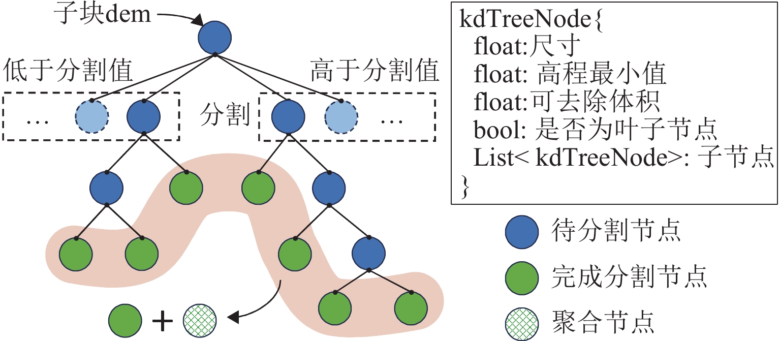
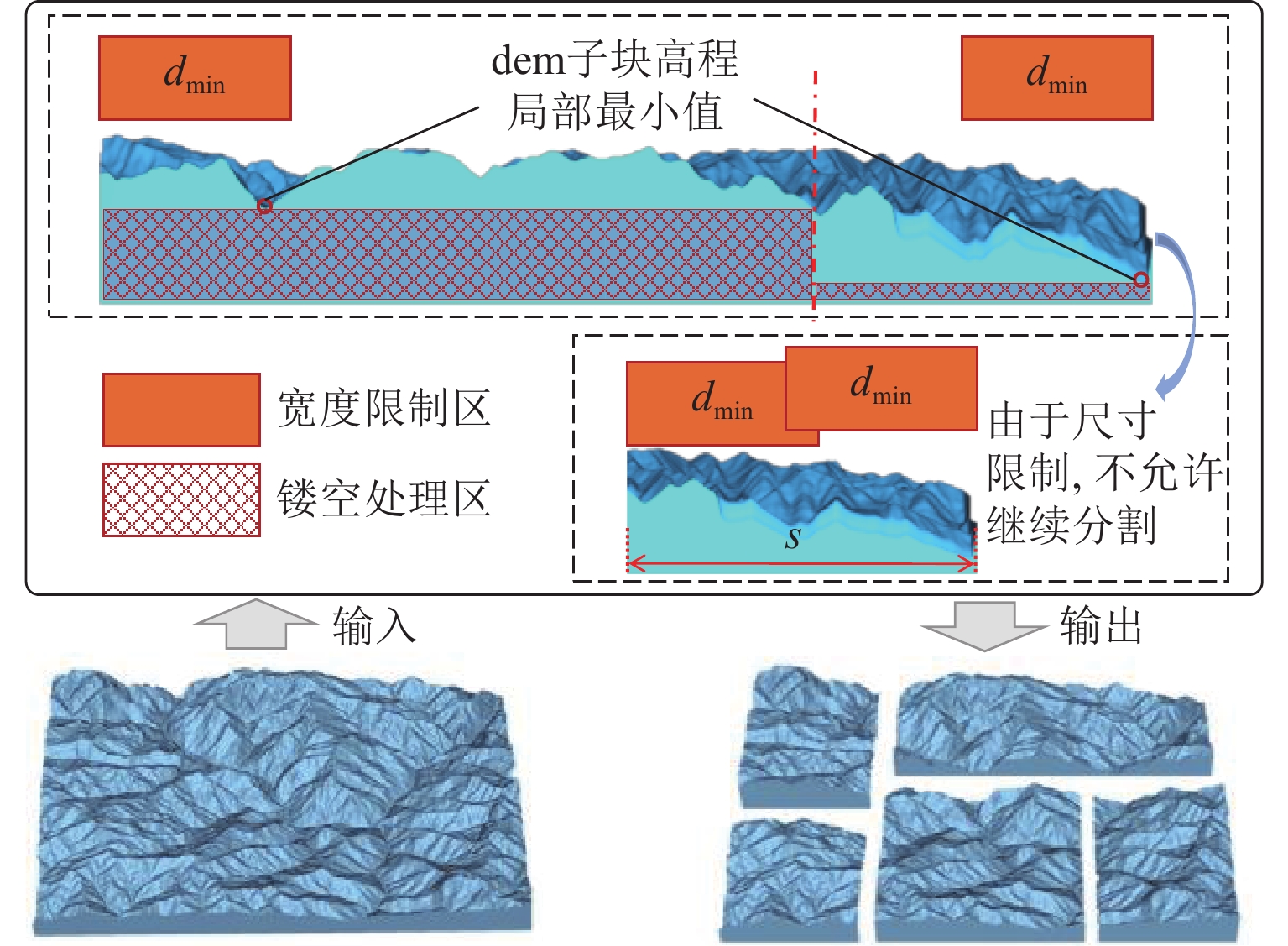
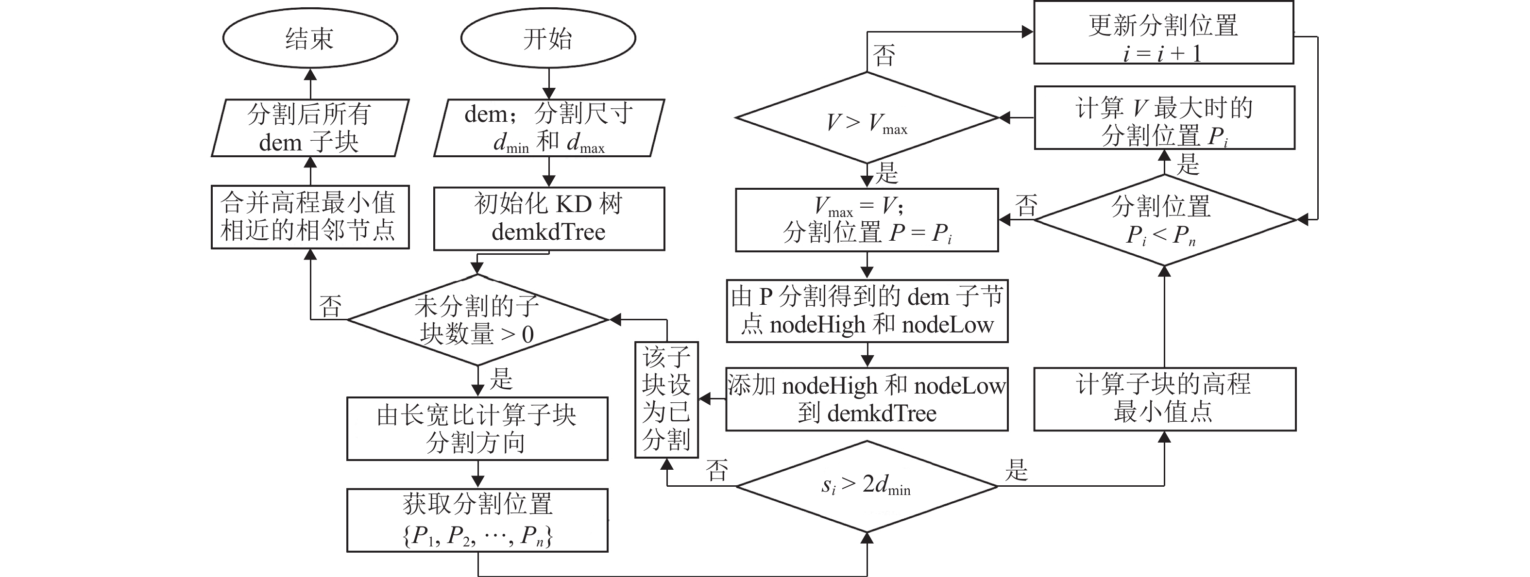
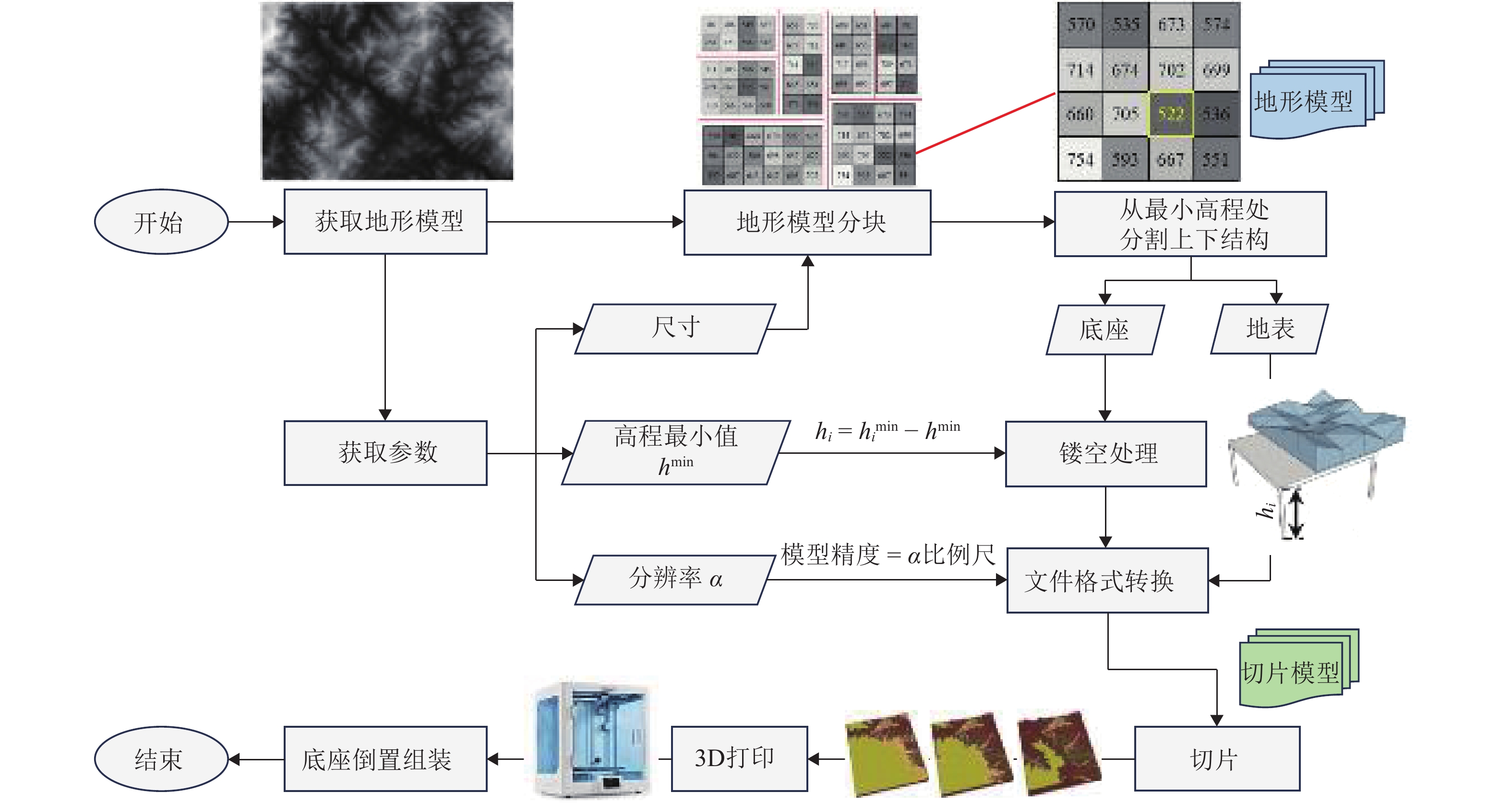
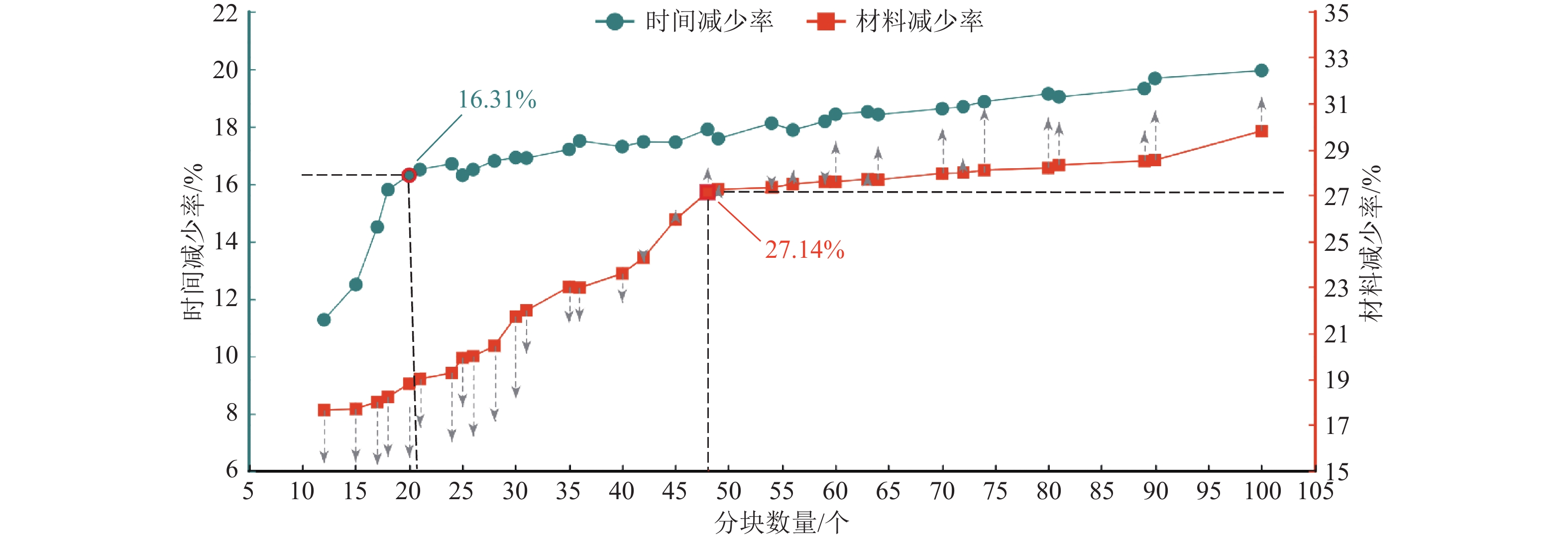
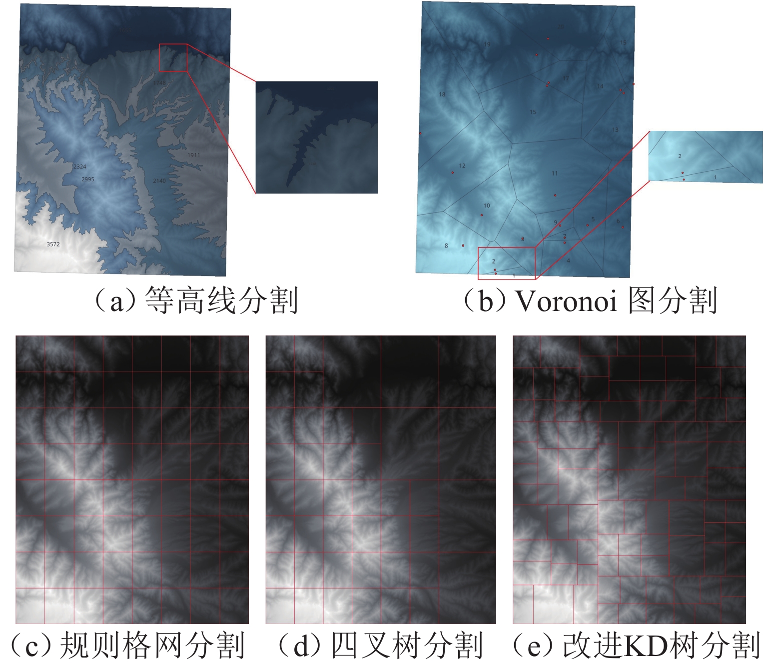
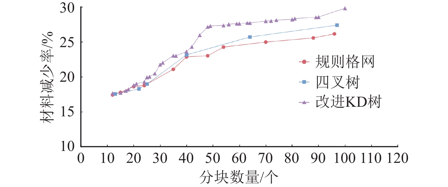
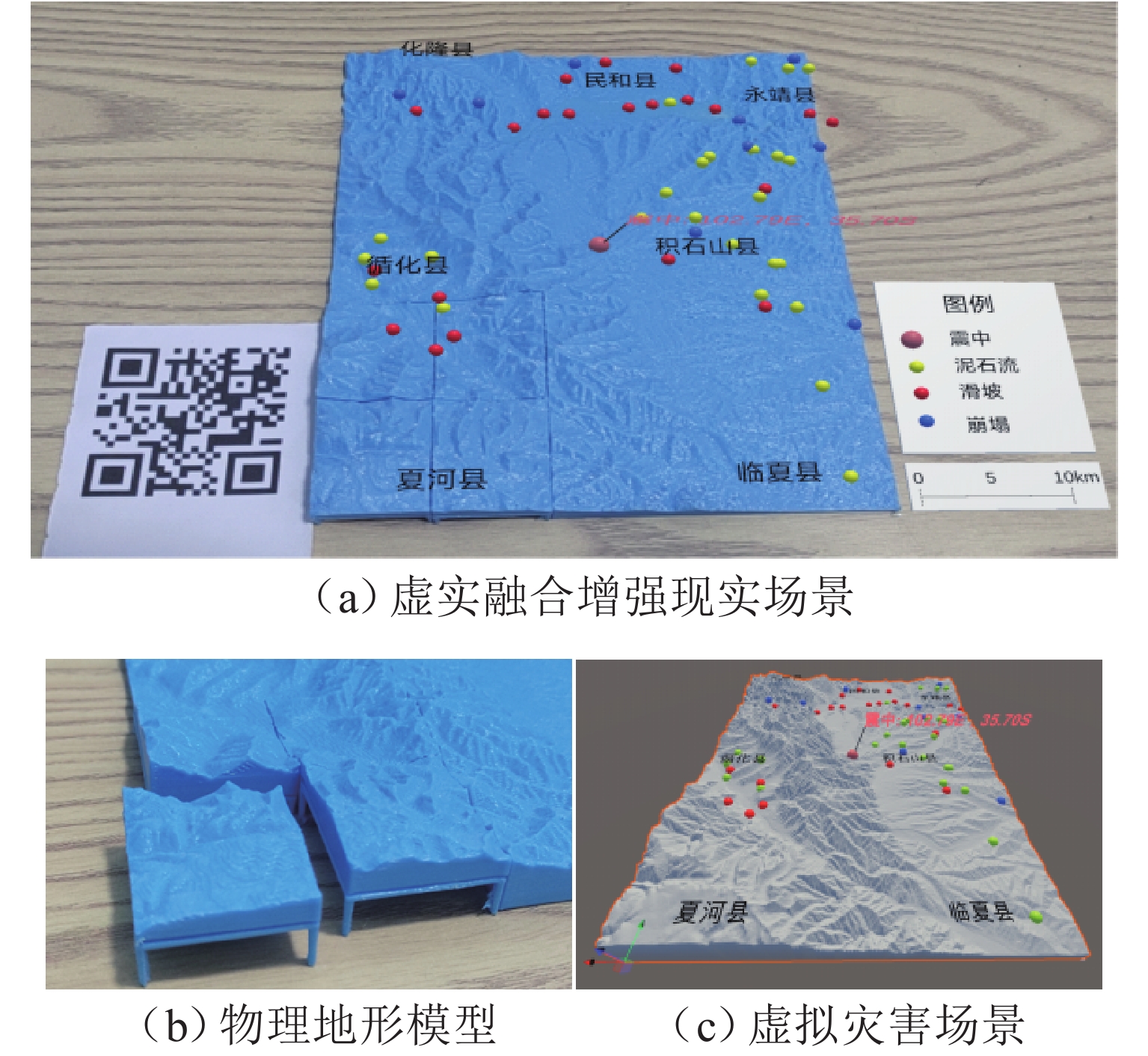
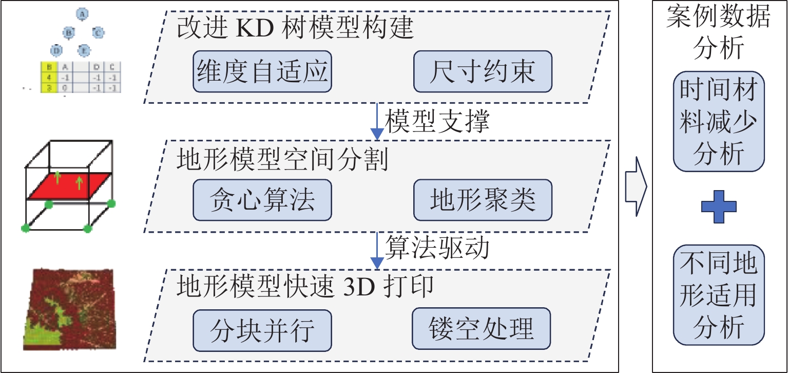
In view of the problems of low efficiency and high cost associated with current three-dimensional (3D) printing methods for fabricating physical terrain models, a rapid printing method for terrain models based on improved K-dimensional (KD) tree spatial segmentation was proposed, aiming to enhance printing efficiency and reduce material consumption. First, the correlation between digital terrain model features and 3D printing parameters was analyzed to establish a rule set of spatial segmentation constraints. Subsequently, an improved KD tree model integrating dimension adaptation and size constraints was constructed, overcoming the rigid limitations of positions and dimensions in traditional segmentation and achieving refined segmentation for the terrain model and effective removal of underground sections. Building upon this foundation, a rapid spatial segmentation algorithm incorporating a greedy strategy was designed. This algorithm maximized the hollowed-out volume of the base by pursuing locally optimal segments. Micro terrain areas were integrated by means of regional clustering to optimize the sub-block segmentation results. For each terrain unit after segmentation, a rapid prototyping method based on block-based parallel and inverted printing was proposed. Fine support structures at four corners prevented model distortion while enabling substantial base hollowing and reducing material consumption and printing time. Finally, an experimental environment was established; case experiments and analysis were carried out; five typical disaster terrain data, including earthquakes, wildfires, floods, landslides, and debris flows, were selected for printing validation under conditions of varying resolutions and spatial scales. Research results demonstrate that the proposed method effectively overcomes the rigid limitations of traditional segmentation and the problem of model sagging distortion in fused deposition modeling. Across cases of the five disaster types, the approach achieves an average reduction of 17.69% in 3D printing time and 28.98% in material consumption. This facilitates rapid and low-cost physical terrain model printing with high applicability across diverse terrains.

| [1] |
MOORMAN L, DJAVAHERPOUR H, ETEMAD K, et al. Geospatial physicalization in geography education[J]. Journal of Geography, 2021, 120(1): 23-35. doi: 10.1080/00221341.2020.1832138
|
| [2] |
CHENRAI P. Case study on geoscience teaching innovation: using 3D printing to develop structural interpretation skill in higher education levels[J]. Frontiers in Earth Science, 2021, 8: 590062. doi: 10.3389/feart.2020.590062
|
| [3] |
ZIEGLER M J, PEREZ V J, PIRLO J, et al. Applications of 3D paleontological data at the Florida museum of natural history[J]. Frontiers in Earth Science, 2020, 8: 600696. doi: 10.3389/feart.2020.600696
|
| [4] |
LI Y, GONG J H, LIU H, et al. Real-time flood simulations using CA model driven by dynamic observation data[J]. International Journal of Geographical Information Science, 2015, 29(4): 523-535. doi: 10.1080/13658816.2014.977292
|
| [5] |
PAJALIĆ S, PERANIĆ J, MAKSIMOVIĆ S, et al. Monitoring and data analysis in small-scale landslide physical model[J]. Applied Sciences, 2021, 11(11): 5040. doi: 10.3390/app11115040
|
| [6] |
王超. 考虑地形影响的雷暴冲击风场特性研究[D]. 重庆: 重庆大学, 2015.
|
| [7] |
GOODWIN S R, CHOI C E, YUNE C Y. Towards rational use of baffle arrays on sloped and horizontal terrain for filtering boulders[J]. Canadian Geotechnical Journal, 2021, 58(10): 1571-1589. doi: 10.1139/cgj-2020-0363
|
| [8] |
AURELI F, MARANZONI A, PETACCIA G, et al. Review of historical dam-break events and laboratory tests on real topography for the validation of numerical models[J]. Water, 2021, 13(14): 1968. doi: 10.3390/w13141968
|
| [9] |
PEARSON H A, DUBÉ A K. 3D printing as an educational technology: theoretical perspectives, learning outcomes, and recommendations for practice[J]. Education and Information Technologies, 2022, 27(3): 3037-3064. doi: 10.1007/s10639-021-10733-7
|
| [10] |
COCKRELL J, PETCOVIC H L. Teaching topography using 3D printed terrain in an introductory earth science course: a pilot study[J]. Journal of Geoscience Education, 2022, 70(1): 2-12. doi: 10.1080/10899995.2021.1927569
|
| [11] |
张忠. 浅谈地图3D打印方法[J]. 测绘, 2018, 41(4): 184-188.
ZHANG Zhong. Research on the 3D printing method of map[J]. Surveying and Mapping, 2018, 41(4): 184-188.
|
| [12] |
李施展. 3D打印技术在香溪长江大桥施工测量中的应用[J]. 测绘通报, 2021(增2): 121-124.
LI Shizhan. Application of 3D printing technology in construction survey of Xiangxi Yangtze River Bridge[J]. Bulletin of Surveying and Mapping, 2021(S2): 121-124.
|
| [13] |
HAUSMAN L A. A simple and rapid method for making relief models from contour maps[J]. Journal of Geography, 1917, 16(3): 97-100. doi: 10.1080/00221341708983769
|
| [14] |
何留喜. 基于DEM数据的纸基3D打印研究[D]. 广州: 华南理工大学, 2016.
|
| [15] |
CARRERA C C, AVARVAREI B V, CHELARIU E L, et al. Map-reading skill development with 3D technologies[J]. Journal of Geography, 2017, 116(5): 197-205. doi: 10.1080/00221341.2016.1248857
|
| [16] |
MOORE A, DANIEL B, LEONARD G, et al. Comparative usability of an augmented reality sandtable and 3D GIS for education[J]. International Journal of Geographical Information Science, 2020, 34(2): 229-250. doi: 10.1080/13658816.2019.1656810
|
| [17] |
HAO J B, JI H S, LIU H, et al. Research on colorized physical terrain modeling for intelligent vehicle navigation[J]. Advances in Mechanical Engineering, 2018, 10(7): 1-13. doi: 10.1177/1687814018787410
|
| [18] |
SOLLA M, CASQUEIRO C, DEL CUVILLO I. Approach to generate 3D-printed terrain models using free software and open data sources: application to military planning[J]. Computer Applications in Engineering Education, 2020, 28(3): 477-489. doi: 10.1002/cae.22211
|
| [19] |
SHAHRUBUDIN N, LEE T C, RAMLAN R. An overview on 3D printing technology: technological, materials, and applications[J]. Procedia Manufacturing, 2019, 35: 1286-1296. doi: 10.1016/j.promfg.2019.06.089
|
| [20] |
刘清, 康二梅. 应用国情普查数据进行3D打印地形沙盘制作方法研究[J]. 矿山测量, 2017, 45(5): 93-96.
LIU Qing, KANG Ermei. Study on the method of making 3D printing topographic sand table in national geography census data[J]. Mine Surveying, 2017, 45(5): 93-96.
|
| [21] |
ESLAHI A, CHADEESINGH D R, FOREMAN C, et al. 3D printers in engineering education[M]// GRAVETT K, YAKOVCHUK N, KINCHIN I M. Enhancing student-centred teaching in higher education: the landscape of student-staff research partnerships. Cham: Springer, 2020: 97-112.
|
| [22] |
李宁威. 3D打印数字地形模型的精细化研究[J]. 青岛大学学报(自然科学版), 2018, 31(增1): 33-37.
LI Ningwei. Research on refinement of 3D printing digital terrain model[J]. Journal of Qingdao University (Natural Science Edition), 2018, 31(S1): 33-37.
|
| [23] |
KIM S, SHIN Y, PARK J, et al. Exploring the potential of 3D printing technology in landscape design process[J]. Land, 2021, 10(3): 259. doi: 10.3390/land10030259
|
| [24] |
王宝成, 李晓亮, 邢辉. 3D地图打印技术研究[J]. 测绘通报, 2017(4): 98-100.
WANG Baocheng, LI Xiaoliang, XING Hui. Research of 3D map printing technology[J]. Bulletin of Surveying and Mapping, 2017(4): 98-100.
|
| [25] |
HASIUK F J, HARDING C, RENNER A R, et al. TouchTerrain: a simple web-tool for creating 3D-printable topographic models[J]. Computers & Geosciences, 2017, 109: 25-31. doi: 10.1016/j.cageo.2017.07.005
|
| [26] |
郝敬宾, 冀寒松, 韩正铜, 等. 地形数字高程模型的物理模型快速成形方法[J]. 计算机辅助设计与图形学学报, 2016, 28(2): 238-246.
HAO Jingbin, JI Hansong, HAN Zhengtong, et al. Rapid prototyping of terrain physical model based on digital elevation model data[J]. Journal of Computer-Aided Design & Computer Graphics, 2016, 28(2): 238-246.
|
| [27] |
WANG H M, CHEN G X, ZHANG W B. 3D printing of topographic map based on UV ink-jet printer[J]. Applied Mechanics and Materials, 2013, 469: 309-312. doi: 10.4028/www.scientific.net/AMM.469.309
|
| [28] |
杨明泽, 王明孝, 马祖光, 等. 三维真彩色地形沙盘模型的自动化制作方法[J]. 地理空间信息, 2017, 15(4): 89-92, 11. doi: 10.3969/j.issn.1672-4623.2017.04.027
YANG Mingze, WANG Mingxiao, MA Zuguang, et al. Automatically production method of 3D true color terrain sand table model[J]. Geospatial Information, 2017, 15(4): 89-92, 11. doi: 10.3969/j.issn.1672-4623.2017.04.027
|
| [29] |
ZHANG G Y, GONG J H, LI Y, et al. An efficient flood dynamic visualization approach based on 3D printing and augmented reality[J]. International Journal of Digital Earth, 2020, 13(11): 1302-1320. doi: 10.1080/17538947.2019.1711210
|
| [30] |
龚建华, 李文航, 张国永, 等. 增强地理环境中过程可视化方法: 以人群疏散模拟为例[J]. 测绘学报, 2018, 47(8): 1089-1097.
GONG Jianhua, LI Wenhang, ZHANG Guoyong, et al. An augmented geographic environment for geo-process visualization: a case of crowd evacuation simulation[J]. Acta Geodaetica et Cartographica Sinica, 2018, 47(8): 1089-1097.
|
| [31] |
HARDING C, HASIUK F, WOOD A, et al. TouchTerrain: 3D printable terrain models[J]. ISPRS International Journal of Geo-Information, 2021, 10(3): 108.
|
| [32] |
STONE B, KAY D, REYNOLDS A, et al. 3D printing and service learning: accessible open educational resources for students with visual impairment[J]. International Journal of Teaching and Learning in Higher Education, 2020, 32(2): 336-346.
|
| [33] |
ISHUTOV S, HODDER K, CHALATURNYK R, et al. A 3D printing short course: a case study for applications in the geoscience teaching and communication for specialists and non-experts[J]. Frontiers in Earth Science, 2021, 9: 601530.
|
| [34] |
ALLAHVERDI K, DJAVAHERPOUR H, MAHDAVI-AMIRI A, et al. Landscaper: a modeling system for 3D printing scale models of landscapes[J]. Computer Graphics Forum, 2018, 37(3): 439-451.
|
| [35] |
DEMETRIOU D, SEE L D, STILLWELL J. A spatial genetic algorithm for automating land partitioning[J]. International Journal of Geographical Information Science, 2013, 27(12): 2391-2409.
|
Figures(9) / Tables(3)


 DownLoad: